IMAGES TAKEN NEAR TO
Sunnyside Place, FROME, BA11 1LH
Introduction
This page details the photographs taken nearby to Sunnyside Place, BA11 1LH by members of the Geograph project.
The Geograph project started in 2005 with the aim of publishing, organising and preserving representative images for every square kilometre of Great Britain, Ireland and the Isle of Man.

There are currently over 7.5m images from over14,400 individuals and you can help contribute to the project by visiting https://www.geograph.org.uk
Image Map
Images are licensed for reuse under creativecommons.org/licenses/by-sa/2.0
Notes
- Clicking on the map will re-center to the selected point.
- The higher the marker number, the further away the image location is from the centre of the postcode.
Image Listing (14 Images Found)
Images are licensed for reuse under creativecommons.org/licenses/by-sa/2.0
Image
Details
Distance
1
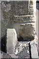
Benchmark on #17 New Buildings
Ordnance Survey cut mark benchmark described on the Bench Mark Database at http://www.bench-marks.org.uk/bm51660
Image: © Roger Templeman
Taken: 20 Sep 2013
0.05 miles
2

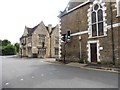
West end of New Buildings at Long Ground junction
There is an OS benchmark Image on the side of the near house right of the guardstone
Image: © Roger Templeman
Taken: 20 Sep 2013
0.05 miles
3

Junction of New Buildings and New Buildings Lane
There is an OS benchmark Image on the side of the house.
Image: © Roger Templeman
Taken: 20 Sep 2013
0.09 miles
4
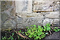
Benchmark on #33 New Buildings
Ordnance Survey cut mark benchmark described on the Bench Mark Database at http://www.bench-marks.org.uk/bm51659
Image: © Roger Templeman
Taken: 20 Sep 2013
0.09 miles
5
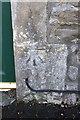
Benchmark on #109 Lock's Hill
Ordnance Survey cut mark benchmark described on the Bench Mark Database at http://www.bench-marks.org.uk/bm51661
Image: © Roger Templeman
Taken: 20 Sep 2013
0.11 miles
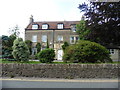
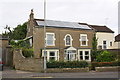
6

Houses on Lock's Hill
There is an OS benchmark Image on the right hand side stone jamb of the dark green door near the left hand side of the image
Image: © Roger Templeman
Taken: 20 Sep 2013
0.11 miles
9
House on west side of Culverhill
There is an OS benchmark Image on the gatepost at left hand edge of the image
Image: © Roger Templeman
Taken: 20 Sep 2013
0.12 miles
10

Benchmark on gatepost beside Culverhill
Ordnance Survey cut mark benchmark described on the Bench Mark Database at http://www.bench-marks.org.uk/bm51662
Image: © Roger Templeman
Taken: 20 Sep 2013
0.13 miles