
IMAGES TAKEN NEAR TO
Weymouth Road, FROME, BA11 1HJ
Introduction
This page details the photographs taken nearby to Weymouth Road, BA11 1HJ by members of the Geograph project.
The Geograph project started in 2005 with the aim of publishing, organising and preserving representative images for every square kilometre of Great Britain, Ireland and the Isle of Man.

There are currently over 7.5m images from over14,400 individuals and you can help contribute to the project by visiting https://www.geograph.org.uk
Image Map
Images are licensed for reuse under creativecommons.org/licenses/by-sa/2.0
Notes
- Clicking on the map will re-center to the selected point.
- The higher the marker number, the further away the image location is from the centre of the postcode.
Image Listing (99 Images Found)
Images are licensed for reuse under creativecommons.org/licenses/by-sa/2.0
Image
Details
Distance
1
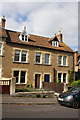
Nos. 74 and 76 Weymouth Road
There is an OS benchmark Image at the right end of the wall at the entrance to #74 (left of the parked car)
Image: © Roger Templeman
Taken: 20 Sep 2013
0.02 miles
2
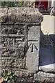
Benchmark on wall end at entrance to #74 Weymouth Road
Ordnance Survey cut mark benchmark described on the Bench Mark Database at http://www.bench-marks.org.uk/bm51773
Image: © Roger Templeman
Taken: 20 Sep 2013
0.02 miles
4
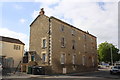
Badcox housing block
There is an OS benchmark Image on the front corner at the far end of the block
Image: © Roger Templeman
Taken: 20 Sep 2013
0.07 miles
5
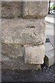
Benchmark on #2 Badcox
Ordnance Survey cut mark benchmark described on the Bench Mark Database at http://www.bench-marks.org.uk/bm51775
Image: © Roger Templeman
Taken: 20 Sep 2013
0.07 miles
6
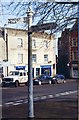
Old Direction Sign - Signpost by Broadway, Frome
Pyramid finial - 2 arms; Somerset SCC pyramid by the UC road, in parish of Frome (Mendip District), Broadway junction with Nunney Road.
Surveyed
Milestone Society National ID: SO_ST7748.
Image: © Milestone Society
Taken: Unknown
0.08 miles
7
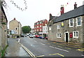
The A362 and the former Ship Inn
The Ship Inn is now the Thai Garden Restaurant. It is late 17C with older origins and is listed, Grade II.
Image: © Humphrey Bolton
Taken: 19 Sep 2013
0.08 miles
8
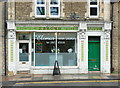
Shop front on the A362, Christchurch Street West
Image: © Humphrey Bolton
Taken: 19 Sep 2013
0.09 miles

10

Frome old fire station
The Old Fire Station, Christchurch Street West, Frome, Somerset was replaced by Image When the photograph was taken it was used by The Fostering Foundation. It is currently (2013) used by a number of small businesses and the ground floor is occupied from the local community radio station FromeFM
Image: © Kevin Hale
Taken: 18 Jun 2007
0.10 miles