
IMAGES TAKEN NEAR TO
Knights Maltings, FROME, BA11 1FJ
Introduction
This page details the photographs taken nearby to Knights Maltings, BA11 1FJ by members of the Geograph project.
The Geograph project started in 2005 with the aim of publishing, organising and preserving representative images for every square kilometre of Great Britain, Ireland and the Isle of Man.

There are currently over 7.5m images from over14,400 individuals and you can help contribute to the project by visiting https://www.geograph.org.uk
Image Map
Images are licensed for reuse under creativecommons.org/licenses/by-sa/2.0
Notes
- Clicking on the map will re-center to the selected point.
- The higher the marker number, the further away the image location is from the centre of the postcode.
Image Listing (7 Images Found)
Images are licensed for reuse under creativecommons.org/licenses/by-sa/2.0
Image
Details
Distance
1
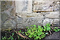
Benchmark on #33 New Buildings
Ordnance Survey cut mark benchmark described on the Bench Mark Database at http://www.bench-marks.org.uk/bm51659
Image: © Roger Templeman
Taken: 20 Sep 2013
0.17 miles
2

Junction of New Buildings and New Buildings Lane
There is an OS benchmark Image on the side of the house.
Image: © Roger Templeman
Taken: 20 Sep 2013
0.18 miles
3
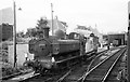
57xx class 0-6-0 pannier tank shunting at Frome, 1963
Over 850 of this versatile class of locomotive were built by the Great Western Railway, capable of working branch passenger services as well as freight. The pannier tank style was almost exclusive to the Great Western Railway among the main line companies.
Image: © Alan Murray-Rust
Taken: Unknown
0.20 miles
4

West end of New Buildings at Long Ground junction
There is an OS benchmark Image on the side of the near house right of the guardstone
Image: © Roger Templeman
Taken: 20 Sep 2013
0.21 miles
5
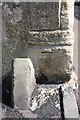
Benchmark on #17 New Buildings
Ordnance Survey cut mark benchmark described on the Bench Mark Database at http://www.bench-marks.org.uk/bm51660
Image: © Roger Templeman
Taken: 20 Sep 2013
0.22 miles
6
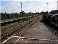
Heart of Wessex Line south from Frome station towards Bruton
Only one platform is in use here in 2015. There is no longer a line alongside the platform on the left, only weeds.
Image: © Jaggery
Taken: 10 Sep 2015
0.24 miles
7
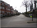
Lock's Hill, Frome
Lock's Hill ascends from the A362 Portway junction.
Image: © Jaggery
Taken: 11 Mar 2017
0.25 miles