IMAGES TAKEN NEAR TO
Sheppards Barton, FROME, BA11 1EL
Introduction
This page details the photographs taken nearby to Sheppards Barton, BA11 1EL by members of the Geograph project.
The Geograph project started in 2005 with the aim of publishing, organising and preserving representative images for every square kilometre of Great Britain, Ireland and the Isle of Man.

There are currently over 7.5m images from over14,400 individuals and you can help contribute to the project by visiting https://www.geograph.org.uk
Image Map (Loading...)


Getting Data...Please wait
Leaflet Map data © OpenStreetMap
Images are licensed for reuse under creativecommons.org/licenses/by-sa/2.0
Notes
- Clicking on the map will re-center to the selected point.
- The higher the marker number, the further away the image location is from the centre of the postcode.
Image Listing (418 Images Found)
Images are licensed for reuse under creativecommons.org/licenses/by-sa/2.0
Image
Details
Distance

2

Cat and window, Shepherd's Barton
Image: © Oast House Archive
Taken: 23 Aug 2013
0.00 miles

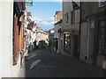
4
Sheppards Barton, Frome
At this point on Catherine Hill, I began to think I had been transported to an Italian hill town. The steps take you beneath number 14 http://www.britishlistedbuildings.co.uk/en-266090-14-catherine-hill-frome-somerset#.V5ac2BL-tuQ .
Image: © Derek Harper
Taken: 17 Jul 2016
0.01 miles
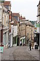
5
Catherine Hill in summer evening sunshine
Image: © David Gearing
Taken: 6 Aug 2011
0.02 miles
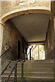
6
Undercroft, Shepherd's Barton
Footpath under building to Catherine's Street.
Image: © Oast House Archive
Taken: 23 Aug 2013
0.02 miles
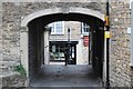
7
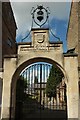
Gateway on Catherine Hill, Frome
Impossible to get this looking straight, as the archway and the gates are at different angles! They are listed and described at http://www.britishlistedbuildings.co.uk/en-266095-screen-gates-and-railings-to-united-refo#.V5b-dBL-tuQ .
The octagonal pyramidal-roofed building on the left seen through archway is the former Sunday School, "a rare survival of the
type" http://www.britishlistedbuildings.co.uk/en-266374-former-sunday-school-frome-somerset#.V5ctOhL-tuQ .
Image: © Derek Harper
Taken: 17 Jul 2016
0.02 miles
8
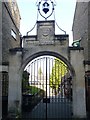
The way to the church
Leading from St Catherine's Hill to the United Reformed Church, the gateway of 1893 is listed, grade II, with details at: https://historicengland.org.uk/listing/the-list/list-entry/1172703
Image: © Michael Dibb
Taken: 11 Dec 2018
0.02 miles