IMAGES TAKEN NEAR TO
Old Vicarage Gardens, BA10 0FG
Introduction
This page details the photographs taken nearby to Old Vicarage Gardens, BA10 0FG by members of the Geograph project.
The Geograph project started in 2005 with the aim of publishing, organising and preserving representative images for every square kilometre of Great Britain, Ireland and the Isle of Man.

There are currently over 7.5m images from over14,400 individuals and you can help contribute to the project by visiting https://www.geograph.org.uk
Image Map
Images are licensed for reuse under creativecommons.org/licenses/by-sa/2.0
Notes
- Clicking on the map will re-center to the selected point.
- The higher the marker number, the further away the image location is from the centre of the postcode.
Image Listing (12 Images Found)
Images are licensed for reuse under creativecommons.org/licenses/by-sa/2.0
Image
Details
Distance
1

Old Direction Sign - Signpost by the A359, Strutter's Hill
Lost finial - 1 arm; Somerset SCC pyramid by the UC road, in parish of Pitcombe (South Somerset District), Strutter's Hill junction with Pitcombe Rock, the lane to Pitcombe.
Surveyed
Milestone Society National ID: SO_ST6733A
Image: © Milestone Society
Taken: Unknown
0.04 miles

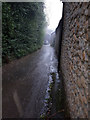
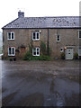
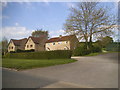
3

Cottages, Mill Lane, Pitcombe
Seen from beneath the disused railway bridge in pouring rain.
Image: © Vieve Forward
Taken: 8 Sep 2017
0.12 miles
4
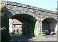
2007 : Railway Viaduct at Pitcombe
The railway over the viaduct has long been dismantled but the right hand arch has been recycled as a car port.
This was the "slow and dirty", officially the Somerset & Dorset Railway. Cole Station was about half a mile north of here, Wincanton was the next stop south.
For more see http://www.railscot.co.uk/Somerset_and_Dorset_Railway/frame.htm
Image: © Maurice Pullin
Taken: 25 Sep 2007
0.14 miles
8
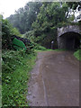
Railway overbridge, Mill Lane, Pitcombe
Disused railway overbridge on former Somerset & Dorset Joint Railway south of Cole. https://en.wikipedia.org/wiki/Somerset_and_Dorset_Joint_Railway
Image: © Vieve Forward
Taken: 8 Sep 2017
0.19 miles
9

2007 : Railway Bridge at Pitcombe
The railway over the bridge is now disused and dismantled.
Image: © Maurice Pullin
Taken: 25 Sep 2007
0.19 miles
10

Remains of railway bridge near former Cole station
Railway bridge just south of former Cole station on disused Somerset & Dorset Joint Railway. https://en.wikipedia.org/wiki/Somerset_and_Dorset_Joint_Railway
Image: © Vieve Forward
Taken: 8 Sep 2017
0.22 miles