IMAGES TAKEN NEAR TO
Brook Street, REDDITCH, B98 8NG
Introduction
This page details the photographs taken nearby to Brook Street, B98 8NG by members of the Geograph project.
The Geograph project started in 2005 with the aim of publishing, organising and preserving representative images for every square kilometre of Great Britain, Ireland and the Isle of Man.

There are currently over 7.5m images from over14,400 individuals and you can help contribute to the project by visiting https://www.geograph.org.uk
Image Map
Images are licensed for reuse under creativecommons.org/licenses/by-sa/2.0
Notes
- Clicking on the map will re-center to the selected point.
- The higher the marker number, the further away the image location is from the centre of the postcode.
Image Listing (9 Images Found)
Images are licensed for reuse under creativecommons.org/licenses/by-sa/2.0
Image
Details
Distance
1
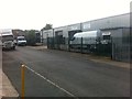
Industrial Buildings, Brook St., Redditch
Image: © Darrin Antrobus
Taken: 9 Jun 2014
0.07 miles
2
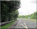
Redditch, Coventry Highway Junction For A441
Image: © Roy Hughes
Taken: 3 Aug 2013
0.11 miles
3
Redditch, Coventry Highway Junction For Alvechurch Highway
Image: © Roy Hughes
Taken: 3 Aug 2013
0.14 miles
4
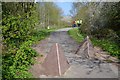
Path guarded by tetrahedral bollards, Arrow Valley Park, Redditch
The path leads from the southern part of the park across Marlfield Lane, behind the camera, into the northern part.
The chaps in high-vis jackets were a party of offenders doing some supervised community service by foraging for litter.
Image: © Robin Stott
Taken: 1 May 2013
0.17 miles
5
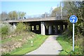
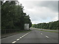
Coventry Highway crosses Arrow Valley Park, Redditch
Arrow Valley Park is a four-kilometre long swathe of naturalistic open space through the east side of Redditch. Here it is at its narrowest, crossed by the fast A4023 dual carriageway. In old Redditch important roads radiated from the heart of the town but in the development of the New Town they were rerouted well away from the town centre, upgraded and landscaped. You can drive through Redditch and believe you are in woodland, hardly seeing a building.
Image: © Robin Stott
Taken: 1 May 2013
0.17 miles
6
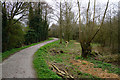
Cycle route in Arrow Valley Country Park
Part of the National Cycle Network route 5. I presume it is raised up as protection against flooding from the River Arrow which is over to the right.
Image: © Bill Boaden
Taken: 17 Mar 2017
0.18 miles
7
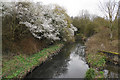
The River Arrow at Redditch
Looking upstream from a footbridge at the bottom of Beoley Road East. It is flowing through the Arrow Valley Country Park, but clearly not very fast.
Image: © Bill Boaden
Taken: 17 Mar 2017
0.20 miles
8
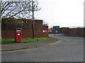
Road Transport Workshop
The Royal Mail's Redditch Road Transport Workshop in the Lakeside Industrial area.
Image: © David Stowell
Taken: 22 Apr 2006
0.21 miles
9
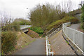
Footpaths and subways in Redditch
The Alvechurch Highway runs high to the right while Holloway Drive runs to the left.
Image: © Bill Boaden
Taken: 17 Mar 2017
0.23 miles