IMAGES TAKEN NEAR TO
Churchill Road, BIRMINGHAM, B9 5NT
Introduction
This page details the photographs taken nearby to Churchill Road, B9 5NT by members of the Geograph project.
The Geograph project started in 2005 with the aim of publishing, organising and preserving representative images for every square kilometre of Great Britain, Ireland and the Isle of Man.

There are currently over 7.5m images from over14,400 individuals and you can help contribute to the project by visiting https://www.geograph.org.uk
Image Map
Images are licensed for reuse under creativecommons.org/licenses/by-sa/2.0
Notes
- Clicking on the map will re-center to the selected point.
- The higher the marker number, the further away the image location is from the centre of the postcode.
Image Listing (16 Images Found)
Images are licensed for reuse under creativecommons.org/licenses/by-sa/2.0
Image
Details
Distance
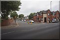
1
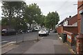
Colonial Road off Bordesley Green, Birmingham
Image: © Ian S
Taken: 23 Jul 2021
0.08 miles

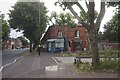
3
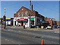
The Avenues Post Office
Interesting re-use of a church building; the stone in the gable (above the dentist's practice) reveals that this former place of worship, probably a Methodist church, was erected in 1928.
Image: © Richard Law
Taken: 21 Apr 2015
0.09 miles
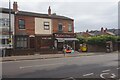
7
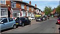
Fourth Avenue
Housing stock typical of this area.
Image: © Peter Mackenzie
Taken: 18 Apr 2017
0.15 miles
8
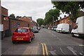
Pretoria Road off Bordesley Green, Birmingham
Image: © Ian S
Taken: 23 Jul 2021
0.18 miles
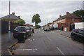
10
Drummond Road off Bordesley Green, Birmingham
Image: © Ian S
Taken: 23 Jul 2021
0.18 miles