IMAGES TAKEN NEAR TO
Rising Lane, SOLIHULL, B94 6JB
Introduction
This page details the photographs taken nearby to Rising Lane, B94 6JB by members of the Geograph project.
The Geograph project started in 2005 with the aim of publishing, organising and preserving representative images for every square kilometre of Great Britain, Ireland and the Isle of Man.

There are currently over 7.5m images from over14,400 individuals and you can help contribute to the project by visiting https://www.geograph.org.uk
Image Map
Images are licensed for reuse under creativecommons.org/licenses/by-sa/2.0
Notes
- Clicking on the map will re-center to the selected point.
- The higher the marker number, the further away the image location is from the centre of the postcode.
Image Listing (19 Images Found)
Images are licensed for reuse under creativecommons.org/licenses/by-sa/2.0
Image
Details
Distance
1
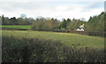
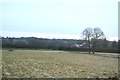
Field and a house by Rising Lane north of Kingswood
This could be the property called The Grove on Open Space maps. Dispersed settlement is an Arden characteristic.
Image: © Robin Stott
Taken: 3 Jan 2013
0.01 miles
2
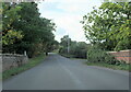
Rising Lane crossing the railway near Lapworth
Image: © Roy Hughes
Taken: 8 Oct 2022
0.08 miles
3
Southbound CrossCountry train near Lapworth
A snatched photo. This is very likely a Newcastle to Southampton service. On this route, instead of going via Birmingham International and Coventry like the Manchester-Bournemouth service, the trains make their way slowly on to the Snow Hill line then run non-stop to Leamington Spa. It's downhill all the way and an exhilarating ride through Solihull and the Arden countryside.
Image: © Robin Stott
Taken: 3 Jan 2013
0.08 miles
4
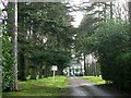
The drive to The Terets, Rising Lane, Kingswood
If you have the money you can buy space, privacy and seclusion with one of the many large houses and grounds scattered through this countryside, many of them built in the 20th century reportedly as weekend retreats for Birmingham businessmen. The Terets is one of the larger examples. The white objects down the drive appear to be akin to outdoor standard lamps.
Image: © Robin Stott
Taken: 3 Jan 2013
0.16 miles
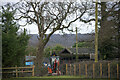
7
Detached houses, west side of Station Road, Kingswood
Image: © Robin Stott
Taken: 3 Jan 2013
0.18 miles
8
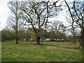
Barns at Uplands Farm, Chessetts Wood Road
Aerial photos show that the farm buildings are more extensive than might be imagined from this photo. The land to the south is occupied by three widely-spaced large houses and grounds. A public footpath leads only to the farm then turns south and back to Chessetts Wood Road: a diversion?
Image: © Robin Stott
Taken: 3 Jan 2013
0.18 miles
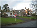
9
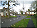
Junction of Station Road and Rising Lane, Kingswood
Image: © Robin Stott
Taken: 3 Jan 2013
0.18 miles
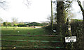
10
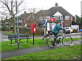
Neighbourhood communications, Station Road, Kingswood
This verge supports a seat, a postbox (B94 116), a street lighting column, two For Sale signs and a Lapworth Parish Council notice board. The gentleman had just posted a letter. In the background is Kingswood Close, all semi-detached houses, in Image
Image: © Robin Stott
Taken: 3 Jan 2013
0.19 miles