IMAGES TAKEN NEAR TO
Valley Lane, SOLIHULL, B94 6HB
Introduction
This page details the photographs taken nearby to Valley Lane, B94 6HB by members of the Geograph project.
The Geograph project started in 2005 with the aim of publishing, organising and preserving representative images for every square kilometre of Great Britain, Ireland and the Isle of Man.

There are currently over 7.5m images from over14,400 individuals and you can help contribute to the project by visiting https://www.geograph.org.uk
Image Map
Images are licensed for reuse under creativecommons.org/licenses/by-sa/2.0
Notes
- Clicking on the map will re-center to the selected point.
- The higher the marker number, the further away the image location is from the centre of the postcode.
Image Listing (32 Images Found)
Images are licensed for reuse under creativecommons.org/licenses/by-sa/2.0
Image
Details
Distance
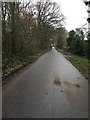
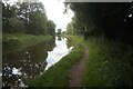
1
Cottages at a lane junction near Chessetts Wood
Although shown as a public footpath the way has more the character of a shared drive or private road.
Image: © Robin Stott
Taken: 5 Jan 2013
0.04 miles
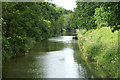
2
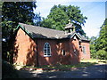
The Old Chapel, Chessetts Wood
The current use is not entirely obvious.
Image: © David Stowell
Taken: 21 Aug 2005
0.11 miles
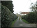
4
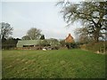
Green barn, Valley Farm near Chessetts Wood
Image: © Robin Stott
Taken: 5 Jan 2013
0.12 miles
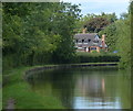
7
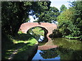
Turnover Bridge, Grand Union Canal, Chessetts Wood
This bridge's primary function is to allow the towpath to change from one side of the canal to the other. Note how the towpath goes through the bridgehole before crossing over, this allowing the towing horses to continue walking without having to drop the towline.
Image: © David Stowell
Taken: 21 Aug 2005
0.13 miles
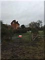
9
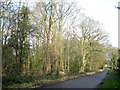
Woodland by Chapel Lane, Chessetts Wood
This is not an old wood, though there may once have been old woodland here. In 1887 it was probably pasture; there was a Wesleyan Methodist chapel at the far corner. The 1905 map shows an orchard, half cleared on the 1925 and subsequent maps, perhaps for a house and grounds. The 1962 map shows mixed trees and scrub. A dense understorey of holly is developing in the centre.
Image: © Robin Stott
Taken: 3 Jan 2013
0.15 miles