IMAGES TAKEN NEAR TO
Tilehouse Green Lane, SOLIHULL, B93 9EZ
Introduction
This page details the photographs taken nearby to Tilehouse Green Lane, B93 9EZ by members of the Geograph project.
The Geograph project started in 2005 with the aim of publishing, organising and preserving representative images for every square kilometre of Great Britain, Ireland and the Isle of Man.

There are currently over 7.5m images from over14,400 individuals and you can help contribute to the project by visiting https://www.geograph.org.uk
Image Map
Images are licensed for reuse under creativecommons.org/licenses/by-sa/2.0
Notes
- Clicking on the map will re-center to the selected point.
- The higher the marker number, the further away the image location is from the centre of the postcode.
Image Listing (12 Images Found)
Images are licensed for reuse under creativecommons.org/licenses/by-sa/2.0
Image
Details
Distance
1
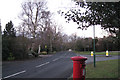
Tilehouse Green Lane
At its junction with the west end of Longdon Road. Postbox number B93 782. The house numbering is from the Solihull direction south towards Dorridge, behind the camera.
Image: © Robin Stott
Taken: 8 Jan 2011
0.04 miles
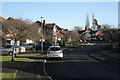
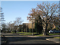
2
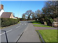
Road junction in Tilehouse Green
At the southern end of the Copt Heath golf course, this is the junction of Browns Lane with Lady Byron Lane (on the left) and Tilehouse Green Lane (on the right)
Image: © Richard Law
Taken: 24 Feb 2016
0.14 miles
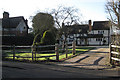
3
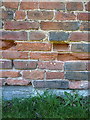
OS benchmark - Tilehouse Green, outbuilding at junction
The rather weathered remains of an OS cutmark on the gable end of a small outbuilding to one of the properties at the road junction; originally levelled at 125.39m above Ordnance Datum Newlyn.
Image: © Richard Law
Taken: 24 Feb 2016
0.15 miles
4
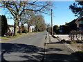
Longdon Road in Tilehouse Green
This one-time quiet lane runs east-west, and connects Tilehouse Green Lane into the centre of Knowle. Earlier maps confirm that the housing developments throughout this area have all been built since the last war.
Image: © Richard Law
Taken: 24 Feb 2016
0.17 miles
5
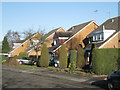
Parallel lines, Spiers Close, Tilehouse Green
Image: © Robin Stott
Taken: 9 Jan 2011
0.20 miles
6
Willowbank Road, Bentley Heath
Looking east from near the brook crossing and Pool End Close.
Image: © Robin Stott
Taken: 9 Jan 2011
0.20 miles
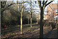
7
Brook north of Smiths Lane
It flows north behind Lady Byron Lane, through rear gardens and under the M42 before joining the river Blythe southeast of Solihull Image
Image: © Robin Stott
Taken: 9 Jan 2011
0.21 miles
8
110 Tilehurst Green Lane
This group of old timber-framed houses is set well back from the road in characteristic Arden fashion, unlike its 20th century neighbours.
Image: © Robin Stott
Taken: 9 Jan 2011
0.22 miles
9
Hallcroft Way, Tilehouse Green
An old oak sticks it out among the ornamentals.
Image: © Robin Stott
Taken: 9 Jan 2011
0.23 miles
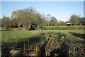
10
Open space by a brook, Bentley Heath
North of Willowbank Road from Pool End Close.
Image: © Robin Stott
Taken: 9 Jan 2011
0.25 miles