IMAGES TAKEN NEAR TO
Darley Green Road, SOLIHULL, B93 8PN
Introduction
This page details the photographs taken nearby to Darley Green Road, B93 8PN by members of the Geograph project.
The Geograph project started in 2005 with the aim of publishing, organising and preserving representative images for every square kilometre of Great Britain, Ireland and the Isle of Man.

There are currently over 7.5m images from over14,400 individuals and you can help contribute to the project by visiting https://www.geograph.org.uk
Image Map
Images are licensed for reuse under creativecommons.org/licenses/by-sa/2.0
Notes
- Clicking on the map will re-center to the selected point.
- The higher the marker number, the further away the image location is from the centre of the postcode.
Image Listing (29 Images Found)
Images are licensed for reuse under creativecommons.org/licenses/by-sa/2.0
Image
Details
Distance
2
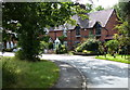
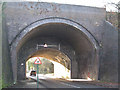
Darley Green Road
Darley Green Road heading under the railway bridge
Image: © Shaun Ferguson
Taken: 22 Sep 2021
0.05 miles
3
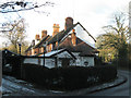
Terraced houses, Darley Green
This isolated terrace occupies a narrow piece of land between Darley Green Road and a high railway embankment.
Image: © Robin Stott
Taken: 5 Dec 2010
0.06 miles
4
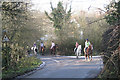
Sunday afternoon ride
A group of girls on horseback is led into Baker's Lane, Darley Green. In an area with a large population of horses, it's good to see some of them being ridden instead of standing around in paddocks looking bored.
Image: © Robin Stott
Taken: 5 Dec 2010
0.06 miles
5
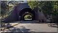
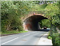
Railway bridge, Darley Green: 1
This massive bridge takes the Snow Hill line over Darley Green Road southeast of Dorridge. An excellent Wikipedia article on Dorridge says that the line was originally four-track between Birmingham and Lapworth but had been reduced to two by the mid-1960s. The form of this bridge suggests that an original two lines were widened to four as commuter traffic developed in mid-Warwickshire from growing communities such as Dorridge. This, the north side, is in blue brick while the lower-height southern span is of orange brick.
Postbox B95 99 is set into the northwest abutment (there is a terrace of houses out of shot, right). B95 is odd because all the postcodes hereabouts are B93.
Road sign appears to warn of ducks. There are brooks nearby.
Image: © Robin Stott
Taken: 5 Dec 2010
0.06 miles
6
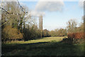
Brook Meadow Nature Reserve SSSI
Owned and managed by Warwickshire Wildlife Trust, it is a herb-rich flood meadow traditionally managed for hay. Seen from the gate at the west end of Baker's Lane.
Image: © Robin Stott
Taken: 5 Dec 2010
0.06 miles
7
Railway bridge across Darley Green Road
Image: © Mat Fascione
Taken: 29 Aug 2015
0.07 miles
8
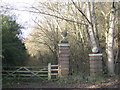
Disused rear drive to 'Parkfield', Darley Green
Image: © Robin Stott
Taken: 5 Dec 2010
0.07 miles
9
Baker's Lane crosses a brook: 2
This brook flows roughly northeast to join the Cuttle Brook, which joins the north-flowing river Blythe near Temple Balsall Image
Image: © Robin Stott
Taken: 5 Dec 2010
0.07 miles
10
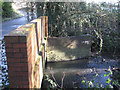
Baker's Lane crosses a brook: 1
This brook flows roughly northeast to join the Cuttle Brook, which joins the north-flowing river Blythe near Temple Balsall Image
Image: © Robin Stott
Taken: 5 Dec 2010
0.08 miles