IMAGES TAKEN NEAR TO
Hillhampton Close, SOLIHULL, B92 9NT
Introduction
This page details the photographs taken nearby to Hillhampton Close, B92 9NT by members of the Geograph project.
The Geograph project started in 2005 with the aim of publishing, organising and preserving representative images for every square kilometre of Great Britain, Ireland and the Isle of Man.

There are currently over 7.5m images from over14,400 individuals and you can help contribute to the project by visiting https://www.geograph.org.uk
Image Map
Images are licensed for reuse under creativecommons.org/licenses/by-sa/2.0
Notes
- Clicking on the map will re-center to the selected point.
- The higher the marker number, the further away the image location is from the centre of the postcode.
Image Listing (12 Images Found)
Images are licensed for reuse under creativecommons.org/licenses/by-sa/2.0
Image
Details
Distance
1
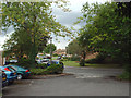
Cophams Close beyond a residents? car park, Olton
This view into the estate is from the dark, dank path alongside the boundary of the vast Land Rover plant.
Image: © Robin Stott
Taken: 14 Aug 2014
0.04 miles
2
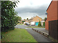
Hillhampton Close, Olton
This entry to the estate leads off the dark, dank path alongside the boundary of the vast Land Rover plant.
Image: © Robin Stott
Taken: 14 Aug 2014
0.05 miles
3
Public footpath from Lode Lane to Elmdon Park, Solihull
For more on this path see Image Here it veers off its historic course and follows a long-vanished field boundary. To the left was the boating pool of Olton Hall, long since built over with housing but visible on the OS Six Inch 188-1913 series map https://maps.nls.uk/geo/explore/side-by-side/#zoom=16&lat=52.44007&lon=-1.77651&layers=6&right=osm . Beyond the fence to the right is the Jaguar Land Rover site.
Image: © A J Paxton
Taken: 29 Aug 2022
0.08 miles
4
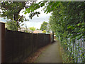
Path to Elmdon Park beside the Land Rover plant, rear of Leafield Road, Olton
No view of the plant is possible along here; it's behind the fence, a 3-metre bank and dense tree scrub on the right.
Image: © Robin Stott
Taken: 14 Aug 2014
0.09 miles
5
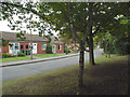
Old people?s bungalows, Cophams Close, Olton
This view into the estate is from the dark, dank path alongside the boundary of the vast Land Rover plant.
Image: © Robin Stott
Taken: 14 Aug 2014
0.10 miles
6
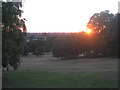
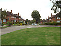
Elmdon Park, Solihull
The western side of Elmdon Park, Solihull (Birmingham City Centre can be seen on the horizon).
Image: © John Evans
Taken: 23 Jul 2006
0.14 miles
7
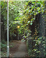
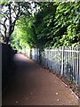
Footpath with street lighting along the boundary of the Land Rover works, Olton
This long, dank, dark path will soon meet Tanhouse Farm Road and Elmdon Park. Low-pressure sodium street lighting is on during the day. The huge works is behind a 3-metre bank behind the chainlink fence here.
Image: © Robin Stott
Taken: 14 Aug 2014
0.19 miles
8
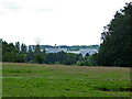
Car factory seen from Elmdon Park
The positions are a best approximation. The car factory is that of Jaguar Land-Rover at Solihull. Elmdon Park is the council owned estate of the now demolished Elmdon Hall.
Image: © Chris Allen
Taken: 26 Jun 2021
0.20 miles
10
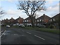
Northwest on Tanhouse Farm Road, Olton
The view is from the corner of Elmdon Park.
Image: © Robin Stott
Taken: 14 Aug 2014
0.22 miles