IMAGES TAKEN NEAR TO
Shalford Road, SOLIHULL, B92 7NE
Introduction
This page details the photographs taken nearby to Shalford Road, B92 7NE by members of the Geograph project.
The Geograph project started in 2005 with the aim of publishing, organising and preserving representative images for every square kilometre of Great Britain, Ireland and the Isle of Man.

There are currently over 7.5m images from over14,400 individuals and you can help contribute to the project by visiting https://www.geograph.org.uk
Image Map
Images are licensed for reuse under creativecommons.org/licenses/by-sa/2.0
Notes
- Clicking on the map will re-center to the selected point.
- The higher the marker number, the further away the image location is from the centre of the postcode.
Image Listing (5 Images Found)
Images are licensed for reuse under creativecommons.org/licenses/by-sa/2.0
Image
Details
Distance
1
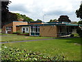
Green Acres Day Care Centre
A former school on Wagon Lane, now converted for use as a day care centre, and under the management of the council's Social Services team.
Image: © Richard Law
Taken: 7 Aug 2014
0.16 miles
2
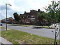
The Dells, Wagon Lane
The Dells, Wagon Lane, in the Lyndon area of Solihull.
Image: © John Evans
Taken: 13 Sep 2006
0.17 miles
3
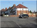
House on Bosworth Road
Photographed from Lincoln Road North at its intersection with Clay Lane and Barn lane.
Image: © Peter Whatley
Taken: 11 Feb 2012
0.19 miles
4
The Lyndon
A large pub/restaurant on the corner of Lyndon Road and Richmond Road.
Image: © Richard Law
Taken: 7 Aug 2014
0.21 miles
5
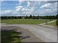
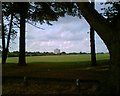
Recreation Ground
A large open area between Lyndon End and Olton.
Image: © Richard Law
Taken: 7 Aug 2014
0.24 miles