1
Clock Tower, Old Warwick Road, Olton
Image: © user
Taken: 30 Sep 2011
0.09 miles
2
Warwick Road (A41)
Note the clock tower on the left.
Image: © Peter Whatley
Taken: 11 Feb 2012
0.09 miles
3
Olton railway station photo-survey (4)
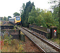
An unidentified 'Voyager' diesel train operated by Cross Country approaching Olton station in the up direction. The train is about to cross the bridge over Richmond Road (see below).
Olton is on the ex-GWR (Great Western Railway) London to Birmingham line. It serves the suburbs of Olton and Ulverley Green about six miles east-southeast of Birmingham city centre. The line was originally built with double track and Olton station had two facing platforms, one either side of the two through lines. However, in the early 1930s the GWR quadrupled the track in the Birmingham area to cope with greatly increased suburban traffic. After quadrupling, Olton station had two island platforms, one serving the two down lines, the other serving the two up lines.
Today, the route is reduced to two tracks again and one of Olton's 1930s island platforms (the one on the east side of the site) serves both the up and down lines. The other island platform is no longer accessible and is very overgrown.
Olton station is operated by London Midland as part of Network West Midlands and is a designated rail/bus interchange point. The majority of train services are operated by London Midland but some Chiltern Railways trains call at Olton.
Image: © Andy F
Taken: 8 Oct 2009
0.09 miles
4
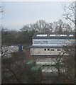
Hemmings & Morris
Image: © N Chadwick
Taken: 22 Feb 2015
0.09 miles
5
Grand Union Canal, Olton, in summer
Looking north-west towards Birmingham along the Grand Union Canal from Olton Bridge (bridge number 84). Compare with the same location in winter [http://www.geograph.org.uk/photo/1255667] .
Image: © Andy F
Taken: 24 Jun 2009
0.10 miles
6
Houses on Braemar Road, Olton
Image: © JThomas
Taken: 4 Apr 2013
0.10 miles
7
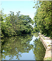
Grand Union Canal near Olton, Solihull
Looking north-west towards Birmingham, the horse-chestnut trees are showing early signs of autumn.
The former Warwick and Birmingham Canal was opened for business in 1800 (though ceremoniously declared open the previous year). It was bought by the Regent's Canal Company in 1929, then absorbed into the Grand Union Canal Company (GUCC) in 1932.
Image: © Roger D Kidd
Taken: 29 Aug 2012
0.10 miles
8
Grand Union Canal, Olton
Looking north-west towards Birmingham along the Grand Union Canal from Olton Bridge (bridge number 84).
Image: © Andy F
Taken: Unknown
0.10 miles
9
Warwick Road, Olton 'Hollow'
Looking down Warwick Road towards Solihull / Birmingham boundary. Clock tower
Image] on left is at junction with Old Warwick Road. The flats on the right are a recent replacement for old houses demolished.
Image: © Michael Westley
Taken: 14 Feb 2010
0.10 miles
10
Richmond Road Bridge No 84
Crossing the Grand Union Canal in Olton.
Image: © Mat Fascione
Taken: 29 Aug 2015
0.10 miles


