IMAGES TAKEN NEAR TO
Church Lane, SOLIHULL, B92 0DT
Introduction
This page details the photographs taken nearby to Church Lane, B92 0DT by members of the Geograph project.
The Geograph project started in 2005 with the aim of publishing, organising and preserving representative images for every square kilometre of Great Britain, Ireland and the Isle of Man.

There are currently over 7.5m images from over14,400 individuals and you can help contribute to the project by visiting https://www.geograph.org.uk
Image Map
Images are licensed for reuse under creativecommons.org/licenses/by-sa/2.0
Notes
- Clicking on the map will re-center to the selected point.
- The higher the marker number, the further away the image location is from the centre of the postcode.
Image Listing (23 Images Found)
Images are licensed for reuse under creativecommons.org/licenses/by-sa/2.0
Image
Details
Distance
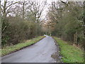
2
Church Lane, Bickenhill
A narrow lane leading north out of the village; it joins the A45 dual carriageway just beyond the parked car, but is narrowed at this end and marked with 'No Entry' signs to discourage vehicular use.
Image: © Richard Law
Taken: 13 Nov 2013
0.11 miles
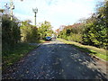
3
Church Lane Bickenhill
A quiet dead-end, cut off by the A45.
Image: © Rod Allday
Taken: 28 Jun 2011
0.11 miles
4
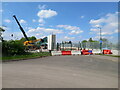
Construction of a new footbridge
The photo shows one of the concrete bridge piers, and a section of the new bridge behind it, which is being built over the A45 as part of a scheme to improve traffic congestion around J6 of the M42 just to the east. That scheme effectively involves a new 'link road' from the M42 a mile or so to the south of here, cutting generally northwards to join into the A45 at the existing Bickenhill interchange. The idea is to reduce congestion at the busy M42/A45 roundabout, by allowing traffic from the south to head directly into Birmingham. The village of Bickenhill will effectively become isolated in a triangle of motorways/dual carriageways, and presumably this footbridge is intended to reduce that isolation, slightly.
Image: © Richard Law
Taken: 21 Apr 2022
0.12 miles
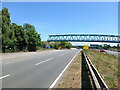
5
New footbridge over the A45
Much of the bridge superstructure has been erected in the few weeks since I took Image from the opposite direction. It's being built as part of a scheme to improve traffic congestion around Junct 6 of the M42 just to the east. That scheme effectively involves a new 'link road' from the M42 a mile or so to the south of here, cutting generally northwards to join into the A45 at the existing Bickenhill interchange. The idea is to reduce congestion at the busy M42/A45 roundabout, by allowing traffic from the south to head directly into Birmingham. The village of Bickenhill will effectively become isolated in a triangle of motorways/dual carriageways, and presumably this footbridge is intended to reduce that isolation, if only slightly.
Image: © Richard Law
Taken: 18 May 2022
0.14 miles
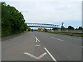
7
New footbridge over the A45
Essentially the same feature as Image, but here the view is from the central reservation of the A45 rather than the pathway on the north side of the road. The access ramps to each end of the new footbridge are yet to be built, but work is in progress.
Image: © Richard Law
Taken: 13 Jul 2022
0.14 miles
9
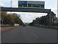
A45 crosses the Rugby-Birmingham railway
The upcoming exit is the extremely important node between A45 and M42, plus the National Exhibition Centre.
Image: © Peter Whatley
Taken: 7 Dec 2011
0.15 miles
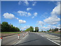
10
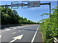
Gantry signs near The Clock roundabout
Image: © Richard Law
Taken: 13 Jul 2022
0.17 miles