IMAGES TAKEN NEAR TO
Wharf Lane, SOLIHULL, B91 2NG
Introduction
This page details the photographs taken nearby to Wharf Lane, B91 2NG by members of the Geograph project.
The Geograph project started in 2005 with the aim of publishing, organising and preserving representative images for every square kilometre of Great Britain, Ireland and the Isle of Man.

There are currently over 7.5m images from over14,400 individuals and you can help contribute to the project by visiting https://www.geograph.org.uk
Image Map
Images are licensed for reuse under creativecommons.org/licenses/by-sa/2.0
Notes
- Clicking on the map will re-center to the selected point.
- The higher the marker number, the further away the image location is from the centre of the postcode.
Image Listing (92 Images Found)
Images are licensed for reuse under creativecommons.org/licenses/by-sa/2.0
Image
Details
Distance
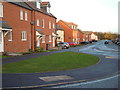
1
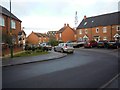
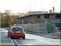
Wharf Lane, Solihull
South West Corner of new development in the centre square of Wharf Lane
Image: © Graham Butcher
Taken: 3 Dec 2011
0.01 miles
2
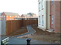
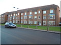
Wharf Lane, Solihull
Entrance to new development (south side) on Wharf Lane
Image: © Graham Butcher
Taken: 3 Dec 2011
0.03 miles
4
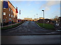
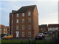
Wharf Lane, Solihull
North side of new development on Wharf Lane
Image: © Graham Butcher
Taken: 3 Dec 2011
0.04 miles
7
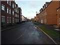
Wharf Lane, Solihull
Near Cornyx Lane
Image: © Graham Butcher
Taken: 3 Dec 2011
0.06 miles
8
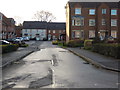
Wharf Lane, Solihull
Off of the main Wharf Lane, but I believe it is still called Wharf Lane
Image: © Graham Butcher
Taken: 3 Dec 2011
0.07 miles
9
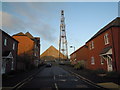
Mobile Phone Pylon
At one of the ends of Wharf Lane, Solihull
Image: © Graham Butcher
Taken: 3 Dec 2011
0.07 miles