IMAGES TAKEN NEAR TO
Lode Lane, SOLIHULL, B91 2HP
Introduction
This page details the photographs taken nearby to Lode Lane, B91 2HP by members of the Geograph project.
The Geograph project started in 2005 with the aim of publishing, organising and preserving representative images for every square kilometre of Great Britain, Ireland and the Isle of Man.

There are currently over 7.5m images from over14,400 individuals and you can help contribute to the project by visiting https://www.geograph.org.uk
Image Map
Images are licensed for reuse under creativecommons.org/licenses/by-sa/2.0
Notes
- Clicking on the map will re-center to the selected point.
- The higher the marker number, the further away the image location is from the centre of the postcode.
Image Listing (88 Images Found)
Images are licensed for reuse under creativecommons.org/licenses/by-sa/2.0
Image
Details
Distance
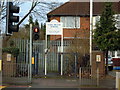
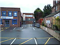
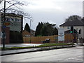
1
Opposite Lode Heath School
Taken from main school entrance across Lode Lane
Image: © Graham Butcher
Taken: 7 Jan 2012
0.01 miles
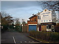
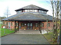
3
Wesley Chapel
At rear of Renewal Centre
Image: © Graham Butcher
Taken: 7 Jan 2012
0.05 miles
5
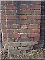
OS benchmark - Lode Heath, school entrance pillar
A slightly damaged OS cutmark on the pillar at the pedestrian entrance to the Lode Heath School; originally levelled at 128.56m above Ordnance Datum Newlyn.
Image: © Richard Law
Taken: 23 Jan 2015
0.05 miles
6
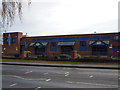
Triple Crown Centre
Taken from Lode Lane
Image: © Graham Butcher
Taken: 28 Dec 2011
0.05 miles
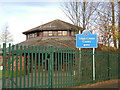
8
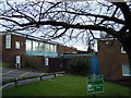
Rear of Learning and Development Centre
Image: © Graham Butcher
Taken: 7 Jan 2012
0.06 miles