IMAGES TAKEN NEAR TO
Coppice Walk, SOLIHULL, B90 4HZ
Introduction
This page details the photographs taken nearby to Coppice Walk, B90 4HZ by members of the Geograph project.
The Geograph project started in 2005 with the aim of publishing, organising and preserving representative images for every square kilometre of Great Britain, Ireland and the Isle of Man.

There are currently over 7.5m images from over14,400 individuals and you can help contribute to the project by visiting https://www.geograph.org.uk
Image Map
Images are licensed for reuse under creativecommons.org/licenses/by-sa/2.0
Notes
- Clicking on the map will re-center to the selected point.
- The higher the marker number, the further away the image location is from the centre of the postcode.
Image Listing (14 Images Found)
Images are licensed for reuse under creativecommons.org/licenses/by-sa/2.0
Image
Details
Distance
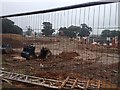
1
Coppice Walk, Cheswick Green
The entrance to Coppice Walk housing estate, from Watery Lane.
Image: © Richard Law
Taken: 4 Mar 2020
0.03 miles
4
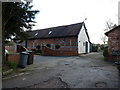
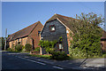
Brook House (former barn) at Forget Me Not Farm
Now converted to a dwelling, this 16th or 17th century former barn was Grade II listed https://britishlistedbuildings.co.uk/101076731-brook-house-cheswick-green & https://historicengland.org.uk/listing/the-list/list-entry/1076731 in 1972.
Image: © Richard Law
Taken: 4 Mar 2020
0.09 miles
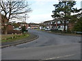
5
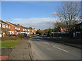
Coppice Walk, Cheswick Green
Some of the 1960s housing development which covers the NE part of this square.
Image: © David Stowell
Taken: 25 Nov 2005
0.09 miles
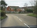
6
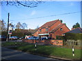
Crossroads Service Station, Cheswick Green
On the edge of the 1960s development in the NE part of this square.
Image: © David Stowell
Taken: 25 Nov 2005
0.09 miles
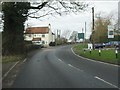
7
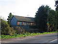
Barn at Forget Me Not Farm, Cheswick Green
Although it is not immediately obvious, this barn has been converted into housing.
Image: © David Stowell
Taken: 25 Nov 2005
0.15 miles
9
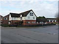
The Saxon public house
A new(ish) pub on a housing estate at Cheswick Green
Image: © Richard Law
Taken: 4 Mar 2020
0.17 miles