IMAGES TAKEN NEAR TO
Ingleton Road, BIRMINGHAM, B8 2QS
Introduction
This page details the photographs taken nearby to Ingleton Road, B8 2QS by members of the Geograph project.
The Geograph project started in 2005 with the aim of publishing, organising and preserving representative images for every square kilometre of Great Britain, Ireland and the Isle of Man.

There are currently over 7.5m images from over14,400 individuals and you can help contribute to the project by visiting https://www.geograph.org.uk
Image Map
Images are licensed for reuse under creativecommons.org/licenses/by-sa/2.0
Notes
- Clicking on the map will re-center to the selected point.
- The higher the marker number, the further away the image location is from the centre of the postcode.
Image Listing (11 Images Found)
Images are licensed for reuse under creativecommons.org/licenses/by-sa/2.0
Image
Details
Distance
1
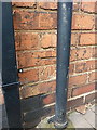
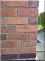
OS benchmark - Ward End, 26 Ingleton Road
An OS cutmark on the soide wall of 26 Ingleton Road; originally levelled at 91.35m above Ordnance Datum Newlyn.
Image: © Richard Law
Taken: 2 Mar 2016
0.11 miles
2
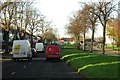
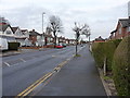
St Margarets Avenue, Ward End
1950s semis along St Margarets Avenue, which leads north to the Bromford Road and the retail & industrial developments around the Fort Dunlop building.
Image: © Richard Law
Taken: 22 Jul 2015
0.14 miles
3
OS benchmark - Ward End, 2 Winnington Road
An OS cutmark on the side wall of no 2 Winnington Road; originally levelled at 91.09m above Ordnance Datum Newlyn.
Image: © Richard Law
Taken: 2 Mar 2016
0.17 miles
4
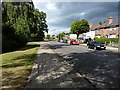
Drews Lane, Bromford
The name Drews Lane is synonymous with the old LDV Vans business, whose assembly plant lay just northwest of here. It went into receivership in 2008, and the factory was demolished a couple of years later.
Image: © Richard Law
Taken: 2 Mar 2016
0.17 miles
5
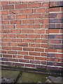
OS benchmark - Ward End, 153 Drews Lane
An OS cutmark on the wall of no 153 Drews Lane; originally levelled at 89.65m above Ordnance Datum Newlyn.
Image: © Richard Law
Taken: 2 Mar 2016
0.18 miles
7

St Margarets Road, Ward End
Older mixed residential and light industrial area, to the east of Ward End.
Image: © Richard Law
Taken: 22 Jul 2015
0.23 miles
8
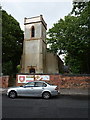
St Margaret's, Ward End
The former St Margaret's Church, which is no longer used for worship, but is the base of a community charity group http://www.stmargaretscommunitytrust.co.uk.
The present church building was erected in the mid 1830s, replacing a much older construction that was in a poor state of repair. It is brick-built, but rendered to simulate a stone construction.
Image: © Richard Law
Taken: 22 Jul 2015
0.24 miles
9

OS benchmark - Ward End, St Margaret's Church
OS benchmark on the southern side of the church tower. Originally levelled at 101.74m above Ordnance Datum Newlyn.
Image: © Richard Law
Taken: 22 Jul 2015
0.24 miles