IMAGES TAKEN NEAR TO
Northleigh Road, BIRMINGHAM, B8 2QJ
Introduction
This page details the photographs taken nearby to Northleigh Road, B8 2QJ by members of the Geograph project.
The Geograph project started in 2005 with the aim of publishing, organising and preserving representative images for every square kilometre of Great Britain, Ireland and the Isle of Man.

There are currently over 7.5m images from over14,400 individuals and you can help contribute to the project by visiting https://www.geograph.org.uk
Image Map (Loading...)


Getting Data...Please wait
Leaflet Map data © OpenStreetMap
Images are licensed for reuse under creativecommons.org/licenses/by-sa/2.0
Notes
- Clicking on the map will re-center to the selected point.
- The higher the marker number, the further away the image location is from the centre of the postcode.
Image Listing (20 Images Found)
Images are licensed for reuse under creativecommons.org/licenses/by-sa/2.0
Image
Details
Distance
1

Ward End Bethel Free Baptist Church
A rather striking building on Wardend Road.
Image: © Richard Law
Taken: 2 Mar 2016
0.08 miles
2
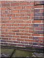
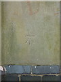
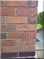
OS benchmark - Ward End, 2 Winnington Road
An OS cutmark on the side wall of no 2 Winnington Road; originally levelled at 91.09m above Ordnance Datum Newlyn.
Image: © Richard Law
Taken: 2 Mar 2016
0.11 miles
3
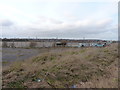
Drews Lane site of LDV Vans
The sad remnants of one of the staff carparks at the once-industrious van manufacturer LDV. They were makers of various models of panel vans and utility vehicles between 1993 and 2008. The business was formed after a buyout by a combined Rover and Leyland team of the Dutch DAF van operation, and manufactured models here such as the Convoy, Pilot, Cub and Maxus. Sadly, it can't be said to have ever truly thrived as a vehicle maker, and eventually fell victim to the global recession of 2008, went into receivership and the assembly lines & equipment were eventually sold off to China's SAIC Motor group in 2010.
Image: © Richard Law
Taken: 2 Mar 2016
0.12 miles
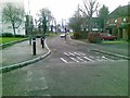
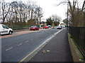
4
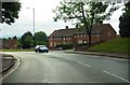
Washwood Heath Road nearing Wallend Road
Image: © Peter Whatley
Taken: 11 Feb 2012
0.17 miles
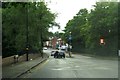
7
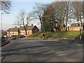
Washwood Heath Road at the junction with Drews Lane
Image: © Richard Law
Taken: 2 Mar 2016
0.19 miles
9
OS benchmark - Ward End, St Margaret's Church
OS benchmark on the southern side of the church tower. Originally levelled at 101.74m above Ordnance Datum Newlyn.
Image: © Richard Law
Taken: 22 Jul 2015
0.20 miles
10
OS benchmark - Ward End, 153 Drews Lane
An OS cutmark on the wall of no 153 Drews Lane; originally levelled at 89.65m above Ordnance Datum Newlyn.
Image: © Richard Law
Taken: 2 Mar 2016
0.20 miles