IMAGES TAKEN NEAR TO
Highgrove Close, TAMWORTH, B79 8RQ
Introduction
This page details the photographs taken nearby to Highgrove Close, B79 8RQ by members of the Geograph project.
The Geograph project started in 2005 with the aim of publishing, organising and preserving representative images for every square kilometre of Great Britain, Ireland and the Isle of Man.

There are currently over 7.5m images from over14,400 individuals and you can help contribute to the project by visiting https://www.geograph.org.uk
Image Map
Images are licensed for reuse under creativecommons.org/licenses/by-sa/2.0
Notes
- Clicking on the map will re-center to the selected point.
- The higher the marker number, the further away the image location is from the centre of the postcode.
Image Listing (22 Images Found)
Images are licensed for reuse under creativecommons.org/licenses/by-sa/2.0
Image
Details
Distance
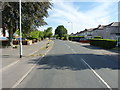
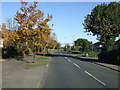
1
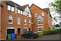
New housing on the west side of Wiggington Road
Ordnance Survey documents indicate that in 1956 a benchmark was levelled at 90.443m above Newlyn Datum at this location on St Editha's hospital. The building was originally (1859) a workhouse, later became St Editha's Hospital and closed in 1998, with many of the buildings demolished and the site developed for residential use
Image: © Roger Templeman
Taken: 3 Aug 2017
0.02 miles
2
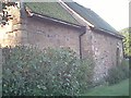
The Spital Chapel
This is the oldest building in Tamworth, possibly partly pre-Norman conquest. It is still used as a Church and has been a Monastery Chapel, a private house, a barn and eventually restored as a place of worship
Image: © Ian Cardinal
Taken: 7 Apr 2004
0.02 miles
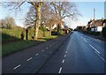
7

Benchmark on #26 Ashby Road
Ordnance Survey cut mark benchmark described on the Bench Mark Database at www.bench-marks.org.uk/bm87338
Image: © Roger Templeman
Taken: 3 Aug 2017
0.11 miles
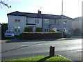
8
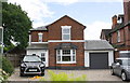
#26 Ashby Road
There is an Ordnance Survey benchmark Image on the left hand side of the house
Image: © Roger Templeman
Taken: 3 Aug 2017
0.12 miles
9
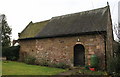
Spital Chapel
The oldest building in Tamworth!
Image: © JamesB
Taken: 28 Jan 2010
0.12 miles