IMAGES TAKEN NEAR TO
Kings Lane, TAMWORTH, B79 0NW
Introduction
This page details the photographs taken nearby to Kings Lane, B79 0NW by members of the Geograph project.
The Geograph project started in 2005 with the aim of publishing, organising and preserving representative images for every square kilometre of Great Britain, Ireland and the Isle of Man.

There are currently over 7.5m images from over14,400 individuals and you can help contribute to the project by visiting https://www.geograph.org.uk
Image Map
Images are licensed for reuse under creativecommons.org/licenses/by-sa/2.0
Notes
- Clicking on the map will re-center to the selected point.
- The higher the marker number, the further away the image location is from the centre of the postcode.
Image Listing (6 Images Found)
Images are licensed for reuse under creativecommons.org/licenses/by-sa/2.0
Image
Details
Distance
1
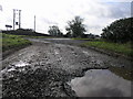
Crossroads With Farm Track
This crossroads is formed by the junction of the B5493, Kings Lane and the farm track in the foreground.
Image: © Michael Patterson
Taken: 16 Feb 2006
0.03 miles
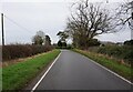
3
King's Lane near Newton Regis
Joining the B5493.
Image: © Alan Murray-Rust
Taken: 11 Jun 2022
0.11 miles
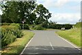
5
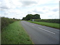
B5493 heading north east
Towards No Man's Heath.
Image: © JThomas
Taken: 21 Jul 2016
0.16 miles
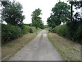
6
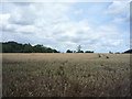
Crop field near No Man's Heath
Off the B5493.
Image: © JThomas
Taken: 21 Jul 2016
0.22 miles