IMAGES TAKEN NEAR TO
Sutton Road, B78 3GA
Introduction
This page details the photographs taken nearby to Sutton Road, B78 3GA by members of the Geograph project.
The Geograph project started in 2005 with the aim of publishing, organising and preserving representative images for every square kilometre of Great Britain, Ireland and the Isle of Man.

There are currently over 7.5m images from over14,400 individuals and you can help contribute to the project by visiting https://www.geograph.org.uk
Image Map
Images are licensed for reuse under creativecommons.org/licenses/by-sa/2.0
Notes
- Clicking on the map will re-center to the selected point.
- The higher the marker number, the further away the image location is from the centre of the postcode.
Image Listing (4 Images Found)
Images are licensed for reuse under creativecommons.org/licenses/by-sa/2.0
Image
Details
Distance
1
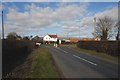
Drayton Lane meeting Sutton Road the A453
Draytonlane End Farm can be seen on the junction.
Image: © Mick Malpass
Taken: 25 Feb 2012
0.17 miles
2
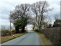
Drayton Lane
Approaching the A453 and Draytonlane End Farm in the centre.
Image: © Jonathan Billinger
Taken: 15 Mar 2010
0.17 miles
3
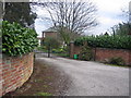
Cranebrook on Drayton Lane
This house is located not far from the Sutton Road.
Image: © Angella Streluk
Taken: 15 Apr 2006
0.25 miles
4
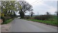
Drayton Lane
View from the same location, looking down Drayton Lane towards Drayton Bassett.
Image: © Angella Streluk
Taken: 15 Apr 2006
0.25 miles