IMAGES TAKEN NEAR TO
South View, TAMWORTH, B78 2NL
Introduction
This page details the photographs taken nearby to South View, B78 2NL by members of the Geograph project.
The Geograph project started in 2005 with the aim of publishing, organising and preserving representative images for every square kilometre of Great Britain, Ireland and the Isle of Man.

There are currently over 7.5m images from over14,400 individuals and you can help contribute to the project by visiting https://www.geograph.org.uk
Image Map
Images are licensed for reuse under creativecommons.org/licenses/by-sa/2.0
Notes
- Clicking on the map will re-center to the selected point.
- The higher the marker number, the further away the image location is from the centre of the postcode.
Image Listing (22 Images Found)
Images are licensed for reuse under creativecommons.org/licenses/by-sa/2.0
Image
Details
Distance
1
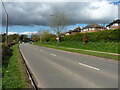
A51 Coventry Road in Kingsbury
Looking north along the main road through Kingsbury
Image: © Richard Law
Taken: 6 Apr 2023
0.07 miles
2
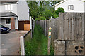
The Heart of England Way at Kingsbury
A narrow path between the houses leading to Kingsbury Meadow.
Image: © Bill Boaden
Taken: 25 May 2019
0.12 miles
3
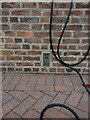
OS benchmark - Kingsbury, 'The Granary' cottage
Located on the wall of one of the converted former Kingsbury Mill buildings, this OS flush bracket was last levelled in 1964 at 65.93m above Ordnance Datum Newlyn. Older maps show an early benchmark on another building in the complex, but that appears to no longer exist.
(The random collection of cabling is part of an electric vehicle charging installation on the house)
Image: © Richard Law
Taken: 6 Apr 2023
0.13 miles
4
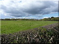
Floodplain of the River Tame near Kingsbury
Over the roadside hedge onto the water meadows alongside the Tame river.
Image: © Richard Law
Taken: 6 Apr 2023
0.13 miles
5
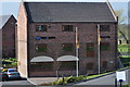
Modern office building to blend with the local old building brickwork
The building is being used by Finance 4 Business who are an independent commercial mortgage and business finance brokerage.
Image: © John Carver
Taken: 29 Mar 2012
0.14 miles
6
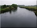
River Tame, Hemlingford
Looking Northwest along the River Tame which has just passed under the reconstructed Hemlingford Bridge. (see Image])
The River Tame used to be one of the most polluted rivers in Britain, thanks mainly to its origins and course through industrial Birmingham, however now it is quite clean and supports a good number of fish.
Image: © Rob Farrow
Taken: 21 Jun 2008
0.15 miles
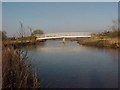
7
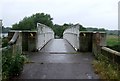
The Replacement Hemlingford Bridge
The old Hemlingford Bridge washed away after a storm some 25 years ago - I took some photos at the time and will have to try to find them. The new bridge is quite stunningly unattractive compared to the C18th one it replaces.
For views of the river at this point see Image] and Image]
Image: © Rob Farrow
Taken: 21 Jun 2008
0.15 miles
8
River Tame at Hemlingford
Riverside view at Hemlingford on outskirts of Kingsbury Water Park
Image: © Michael Westley
Taken: 24 Mar 2018
0.15 miles
9
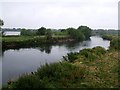
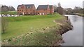
River Tame & part of Water Park
The old gravel workings besides the River Tame in Kingsbury have long been full of water and are nowadays a water park. One of the lakes can just be glimpsed beyond the course of the river. See also Image] for another view of the river.
Image: © Rob Farrow
Taken: 21 Jun 2008
0.15 miles
10
Hemingford Bridge crosses the River Tame
Image: © Tim Glover
Taken: 4 Jan 2003
0.16 miles