IMAGES TAKEN NEAR TO
Colonel Dibley Close, TAMWORTH, B78 2FD
Introduction
This page details the photographs taken nearby to Colonel Dibley Close, B78 2FD by members of the Geograph project.
The Geograph project started in 2005 with the aim of publishing, organising and preserving representative images for every square kilometre of Great Britain, Ireland and the Isle of Man.

There are currently over 7.5m images from over14,400 individuals and you can help contribute to the project by visiting https://www.geograph.org.uk
Image Map
Images are licensed for reuse under creativecommons.org/licenses/by-sa/2.0
Notes
- Clicking on the map will re-center to the selected point.
- The higher the marker number, the further away the image location is from the centre of the postcode.
Image Listing (10 Images Found)
Images are licensed for reuse under creativecommons.org/licenses/by-sa/2.0
Image
Details
Distance
1
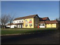
The Sportsman's Arms, Piccadilly
This quite new pub and restaurant, built maybe 20 years ago serves Piccadilly, which until it was built did not have a pub that I'm aware of, though I think it may have had a Working Men's Club. Perryman Drive which leads up to it was built at the same time and is named after Steve Perry - a very good sportsman in his time - and the father of the builder and original owner of the pub.
[Edit] I'm reliably informed that, rather than having been built from scratch, the pub as it is now is actually a conversion of the pre-existing Working Men's Club to which I alluded above.
Image: © Rob Farrow
Taken: 7 Dec 2008
0.00 miles
2
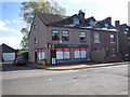
The Post Office, Piccadilly
This small village is fortunate to still have a Post Office. Mining used to be the main employer here, but now there are no mines.
Image: © Angella Streluk
Taken: 25 Oct 2005
0.07 miles
3
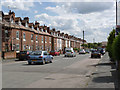
Piccadilly, Kingsbury
A single wide street, lined with miners' terraced houses, adjacent to the former Kingsbury Colliery. Built in the early years of the 20th century, it formed the only residential group close to the mine until the development of the adjacent Piccadilly Crescent by the National Coal Board around 1950.
Image: © Alan Murray-Rust
Taken: 5 Jun 2014
0.08 miles
4
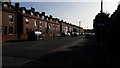
Housing in Piccadilly
Terraced houses in Piccadilly near to Kingsbury.
Image: © Peter Mackenzie
Taken: 16 Oct 2017
0.09 miles
5
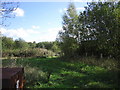
Woodland to the rear of Piccadilly Post Office
This area is marked on the map as a Danger Area. this is due to the fact that there is a rifle range nearby.
Image: © Angella Streluk
Taken: 25 Oct 2005
0.09 miles
6
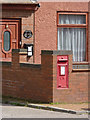
The Old Post Office, Piccadilly
The isolated pair of terraces http://www.geograph.org.uk/photo/4034705 forming Piccadilly once had their own Post Office. The house name and postbox (GR wall box, ref B78 91) are the only reminders. In practice, even the postbox is not in its original position. Compare with http://www.geograph.org.uk/photo/70101
Image: © Alan Murray-Rust
Taken: 5 Jun 2014
0.11 miles
7
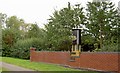
Miner's lamp Piccadilly
The wall is built of bricks each of which has been bought by the families of miners who worked at nearby Dexter and Kingsbury Collieries.
The miner’s lamp will light up and stay lit as an everlasting flame to commemorate those who have died and those who remember working down the mines.
Image: © Steve Fareham
Taken: 17 Sep 2009
0.12 miles
8
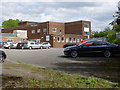
Industrial buildings, Piccadilly
These are the former pithead baths for the otherwise vanished Kingsbury Colliery.
Image: © Alan Murray-Rust
Taken: 5 Jun 2014
0.14 miles
9
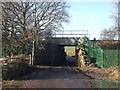
Slateley Railway Bridge, Piccadilly - from SE
This little bridge carries an offshoot of the main railway line across the bridleway from Piccadilly to Image This is the view northwestwards, i.e. from the Piccadilly side looking towards Slateley. The view from the other side can be seen here Image]
This line used to be used to bring coal from the former Birch Coppice Colliery, and also passes by Image] where there are sidings. The colliery is now closed, but the line is set to get even busier as it now terminates at the Image
Image: © Rob Farrow
Taken: 7 Dec 2008
0.19 miles
10
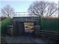
Slateley Railway Bridge, Piccadilly - From NW
This little bridge carries an offshoot of the main railway line across the bridleway from Image] via Image] to Piccadilly. This is the view southeastwards, i.e. from the Slateley side looking towards Piccadilly. The view from the other side can be seen here Image]
This line used to be used to bring coal from the former Birch Coppice Colliery, and also passes by Image] where there are sidings. The colliery is now closed, but the line is set to get even busier as it now terminates at the Image
Image: © Rob Farrow
Taken: 7 Dec 2008
0.19 miles