IMAGES TAKEN NEAR TO
Abbott Road, TAMWORTH, B78 1PD
Introduction
This page details the photographs taken nearby to Abbott Road, B78 1PD by members of the Geograph project.
The Geograph project started in 2005 with the aim of publishing, organising and preserving representative images for every square kilometre of Great Britain, Ireland and the Isle of Man.

There are currently over 7.5m images from over14,400 individuals and you can help contribute to the project by visiting https://www.geograph.org.uk
Image Map
Images are licensed for reuse under creativecommons.org/licenses/by-sa/2.0
Notes
- Clicking on the map will re-center to the selected point.
- The higher the marker number, the further away the image location is from the centre of the postcode.
Image Listing (58 Images Found)
Images are licensed for reuse under creativecommons.org/licenses/by-sa/2.0
Image
Details
Distance

3

New housing in Polesworth
Adjacent to the Coventry Canal.
Image: © Andrew Abbott
Taken: 1 May 2023
0.05 miles
4
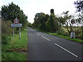
Grendon Road (B5000)
Heading east leaving Polesworth.
Image: © JThomas
Taken: 2 Nov 2013
0.08 miles
5
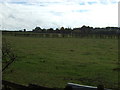
Grazing near Polesworth
South of Grendon Road.
Image: © JThomas
Taken: 2 Nov 2013
0.10 miles
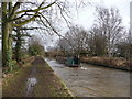
6
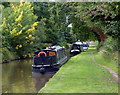
Narrowboats moored along the Coventry Canal
This stretch of the canal is between bridges 50b and 51.
Image: © Mat Fascione
Taken: 13 Sep 2015
0.10 miles
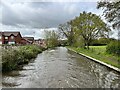
7
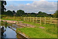
Overflow weir on the Coventry Canal at Polesworth
Image: © David Martin
Taken: 18 Jul 2016
0.10 miles
9
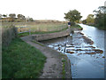
Coventry Canal overflow east of Polesworth
The channel heads west to join the River Anker. In the background is the West Coast main line and Stiper's Hill, left. A lone runner returns to the village at the end of a cold November afternoon.
Image: © Robin Stott
Taken: 2 Nov 2012
0.11 miles
10
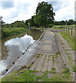
Overflow along the Coventry Canal
The overflow drains any excess water into the River Anker.
Image: © Mat Fascione
Taken: 13 Sep 2015
0.11 miles