IMAGES TAKEN NEAR TO
Summerfield Road, TAMWORTH, B77 3PG
Introduction
This page details the photographs taken nearby to Summerfield Road, B77 3PG by members of the Geograph project.
The Geograph project started in 2005 with the aim of publishing, organising and preserving representative images for every square kilometre of Great Britain, Ireland and the Isle of Man.

There are currently over 7.5m images from over14,400 individuals and you can help contribute to the project by visiting https://www.geograph.org.uk
Image Map
Images are licensed for reuse under creativecommons.org/licenses/by-sa/2.0
Notes
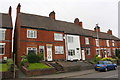
- Clicking on the map will re-center to the selected point.
- The higher the marker number, the further away the image location is from the centre of the postcode.
Image Listing (56 Images Found)
Images are licensed for reuse under creativecommons.org/licenses/by-sa/2.0
Image
Details
Distance
1

William MacGregor Primary School
There is an Ordnance Survey benchmark Image just past the near buttress end on the left hand face of the building
Image: © Roger Templeman
Taken: 29 Aug 2017
0.12 miles
2

Benchmark on William MacGregor County Primary School
Ordnance Survey cut mark benchmark described on the Bench Mark Database at www.bench-marks.org.uk/bm89199
Image: © Roger Templeman
Taken: 29 Aug 2017
0.13 miles
3

Benchmark on the northeast side of #84 Amington Road
Ordnance Survey cut mark benchmark described on the Bench Mark Database at www.bench-marks.org.uk/bm88434
Image: © Roger Templeman
Taken: 29 Aug 2017
0.13 miles


6
Nos. 84, 82, 80, etc Amington Road
There is an Ordnance Survey benchmark Image on the side (up alleyway) of the left hand house near its front corner
Image: © Roger Templeman
Taken: 29 Aug 2017
0.14 miles
7

Benchmark on wall on northwest side of Amington Road
Ordnance Survey cut mark benchmark described on the Bench Mark Database at www.bench-marks.org.uk/bm88433
Image: © Roger Templeman
Taken: 29 Aug 2017
0.15 miles
8
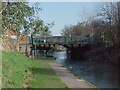
Anchor Bridge
This is numbered 73 and carries the B5000 over the Coventry Canal
Image: © Tim Glover
Taken: 15 Feb 2003
0.15 miles
9
Amington Road, Bolehall
Bolehall was recorded as a manor in medieval times and was part of Warwickshire until 1889. Although the area developed from the late 18th century onwards with coal mining and clay extraction, as well as a tape mill in the 19th century, major expansion occurred in the mid-20th century as a suburb of Tamworth. The semi-detached houses seen here at the junction of Amington Road and Manor Road date from that time.
Image: © Stephen McKay
Taken: 7 Apr 2021
0.15 miles