IMAGES TAKEN NEAR TO
Robertsons Gardens, BIRMINGHAM, B7 5NL
Introduction
This page details the photographs taken nearby to Robertsons Gardens, B7 5NL by members of the Geograph project.
The Geograph project started in 2005 with the aim of publishing, organising and preserving representative images for every square kilometre of Great Britain, Ireland and the Isle of Man.

There are currently over 7.5m images from over14,400 individuals and you can help contribute to the project by visiting https://www.geograph.org.uk
Image Map (Loading...)


Getting Data...Please wait
Leaflet Map data © OpenStreetMap
Images are licensed for reuse under creativecommons.org/licenses/by-sa/2.0
Notes
- Clicking on the map will re-center to the selected point.
- The higher the marker number, the further away the image location is from the centre of the postcode.
Image Listing (47 Images Found)
Images are licensed for reuse under creativecommons.org/licenses/by-sa/2.0
Image
Details
Distance
1
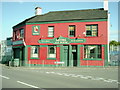
The Mitre Pub
On the junction of Railway Terrace and Long Acre.
Image: © Carl Baker
Taken: 9 Oct 2006
0.08 miles
2
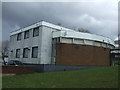
Ramp up to Long Acre, Aston, Birmingham
Photographed from a Lichfield-New Street train.
Image: © Robin Stott
Taken: 25 Jul 2016
0.11 miles
3
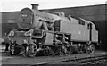
Stanier 4MT 2-6-4T at Aston Locomotive Depot
A pre-Nationalisation view of No. 2616 (built 1937, withdrawn 9/67 - the Last of the Class, and none are preserved).
Image: © Ben Brooksbank
Taken: 30 Mar 1946
0.12 miles
4
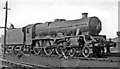
Stanier 'Jubilee' 4-6-0 at Aston Locomotive Depot
Proud-looking 'Jubilee' No. 5733 'Novelty' (built 11/36, withdrawn 9/64) is being prepared for the road, still in LMS livery - in 1946. [One of my earliest and better 'portraits']. Aston Depot provided motive power for ex-LNW passenger and freight traffic north from Birmingham: at that time (coded 3D) it had an allocation of 53:- 7 4-6-0, 6 2-6-0, 9 0-8-0, 15 0-6-0, 7 2-6-4T, 4 2-6-2T and 5 0-6-0T.
Image: © Ben Brooksbank
Taken: 30 Mar 1946
0.12 miles
5
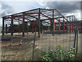
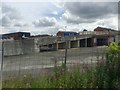
Steel frame near Long Acre, Aston, Birmingham
An aerial photo shows the building complete. Photographed from a Lichfield-New Street local train just past Aston station.
Image: © Robin Stott
Taken: 25 Jul 2016
0.16 miles
7

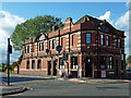
The Villa Tavern
Built in 1897, and on the corner of Nechells Park Road and Holborn Hill.
Image: © Richard Law
Taken: 26 Aug 2015
0.17 miles
8
The Villa Tavern in Nechells, Birmingham
The Villa Tavern, originally built in 1897, but rebuilt 1924-1925 following a fire is Grade II listed, and is on the corner of Holborn Hill and Nechells Park Road.
When I visited in 2012 no real ale was available.
Image: © Roger Kidd
Taken: 20 Aug 2012
0.17 miles
9

Holborn Hill and Villa Tavern in Birmingham
The Villa Tavern, originally built in 1897, but rebuilt 1924-1925 following a fire is Grade II listed, and is on the corner of Holborn Hill and Nechells Park Road. Beyond the crossroads are the former public baths (opened in 1910) in Aston Church Road.
When I visited in 2012 no real ale was available.
Image: © Roger Kidd
Taken: 20 Aug 2012
0.17 miles
10
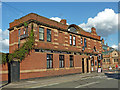
The Villa Tavern in Nechells, Birmingham
The Villa Tavern, originally built in 1897, but rebuilt 1924-1925 following a fire is Grade II listed, and is on the corner of Holborn Hill and Nechells Park Road.
When I visited in 2012 no real ale was available. Beyond the crossroads are the former public baths (opened in 1910) in Aston Church Road.
Image: © Roger Kidd
Taken: 20 Aug 2012
0.17 miles