IMAGES TAKEN NEAR TO
Rocky Lane, BIRMINGHAM, B7 5ES
Introduction
This page details the photographs taken nearby to Rocky Lane, B7 5ES by members of the Geograph project.
The Geograph project started in 2005 with the aim of publishing, organising and preserving representative images for every square kilometre of Great Britain, Ireland and the Isle of Man.

There are currently over 7.5m images from over14,400 individuals and you can help contribute to the project by visiting https://www.geograph.org.uk
Image Map (Loading...)


Getting Data...Please wait
Leaflet Map data © OpenStreetMap
Images are licensed for reuse under creativecommons.org/licenses/by-sa/2.0
Notes
- Clicking on the map will re-center to the selected point.
- The higher the marker number, the further away the image location is from the centre of the postcode.
Image Listing (90 Images Found)
Images are licensed for reuse under creativecommons.org/licenses/by-sa/2.0
Image
Details
Distance
1
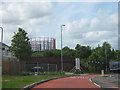
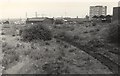
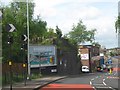
Disused Railway Embankment, Rocky Lane, Aston With Claret & Blue Gasometers in distance
Image] The locations are extremely close whilst the angle may be a little out - so much has changed at this location.
Image: © Roy Hughes
Taken: 9 May 2009
0.00 miles
2
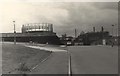
Gas Works near Rupert Street / Walter Street junction, Aston
View from B4144 (as is now) whilst the Windsor Street Wharf goods line (on right) was still intact, but not used. The line was even electrified. The gas towers on left remain intact today Image
The buildings in front of gas towers were demolished later. On the corner of Rupert Street, a Public House has been built since, become dilapidated and then demolished.
Straight ahead can be seen the BT tower in central Birmingham, and to left of this is the tall office block on inner ring-road A4540 near to Birmingham and Fazeley Canal.
Image: © Michael Westley
Taken: Unknown
0.02 miles
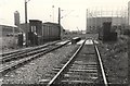
3
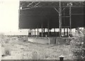
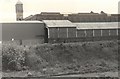
Former Windsor Street Wharf Goods Station
View of former goods station platforms on large expanse of unused land alongside Rupert Street.
Image: © Michael Westley
Taken: Unknown
0.03 miles
4
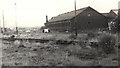
Former Windsor Street Wharf goods railway line
Track in front of goods buildings near to Rocky Lane and Rupert Street junction.
Image: © Michael Westley
Taken: Unknown
0.05 miles
5
Former Windsor Street Wharf goods sidings
Looking up a slight incline in direction of Rocky Lane. Block of flats on right is at junction of Rocky Lane and Cromwell Street. Just to left of this, can be seen one of the gas towers (that still exist) on Heartlands Parkway near to Star City.
Image: © Michael Westley
Taken: Unknown
0.06 miles
6
Former Windsor Street Wharf goods railway line
Looking south-west across Rocky Lane railway bridge, one of the 3 gas towers can be seen on the right.
Image: © Michael Westley
Taken: Unknown
0.06 miles
7
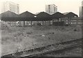
Former Windsor Street Wharf Goods Station, Aston
Covered former goods platforms running parallel to Rupert Street (houses behind) and behind that 3 high rise blocks of flats on Cromwell Street.
Image: © Michael Westley
Taken: Unknown
0.07 miles
8
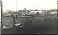
Former Windsor Street Wharf
View from former goods platforms looking west. HP Sauce factory can be seen on skyline (now dismantled), in front of which is Rocky Lane itself.
Image: © Michael Westley
Taken: Unknown
0.09 miles
9
Dismantled Railway Bridge, Rocky Lane, Aston.
Image: © Roy Hughes
Taken: 9 May 2009
0.09 miles
10
Former Windsor Street Wharf Goods Station
View of 2 elevations within the goods station site. Building on upper elevation ran parallel to Rupert Street.
Image: © Michael Westley
Taken: Unknown
0.09 miles