IMAGES TAKEN NEAR TO
Lindridge Road, SUTTON COLDFIELD, B75 7HY
Introduction
This page details the photographs taken nearby to Lindridge Road, B75 7HY by members of the Geograph project.
The Geograph project started in 2005 with the aim of publishing, organising and preserving representative images for every square kilometre of Great Britain, Ireland and the Isle of Man.

There are currently over 7.5m images from over14,400 individuals and you can help contribute to the project by visiting https://www.geograph.org.uk
Image Map
Images are licensed for reuse under creativecommons.org/licenses/by-sa/2.0
Notes
- Clicking on the map will re-center to the selected point.
- The higher the marker number, the further away the image location is from the centre of the postcode.
Image Listing (7 Images Found)
Images are licensed for reuse under creativecommons.org/licenses/by-sa/2.0
Image
Details
Distance
1
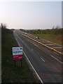
Welcome to Birmingham
So says the sign, as the A38 Sutton Coldfield by-pass passes under Lindridge Road and over the City boundary, still well in open countryside.
Image: © Martin Fisher
Taken: 31 Mar 2007
0.11 miles
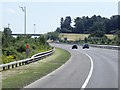
2
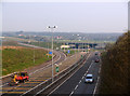
Northwards view of A38 Sutton Coldfield By-pass, from Lindridge Road
Showing the slip-road to M6 Toll junction T3
Image: © Martin Fisher
Taken: 31 Mar 2007
0.11 miles
3
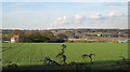
Cross fields to M6 Toll, near Wishaw
From Holley Lane, close to Lindridge Road, looking north-west towards M6 Toll road (J3) and New Park Woods beyond - you can just see booths on right of photo. Building on left is 'The Kennels'.
Image: © Michael Westley
Taken: 15 Nov 2010
0.16 miles
4
Tollbooth on the M6 Toll
This is the exit onto the A38.
Image: © Alan Murray-Rust
Taken: 15 May 2011
0.17 miles
5

M6 toll plaza
At sunset near Sutton Coldfield.
Image: © Derek Harper
Taken: 28 Dec 2022
0.20 miles
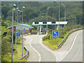
7
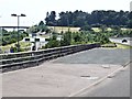
M6 Toll Road, Grove End
Toll booths on the slip road at Junction T3.
Image: © David Dixon
Taken: 1 Aug 2013
0.22 miles