IMAGES TAKEN NEAR TO
Great Brook Street, BIRMINGHAM, B7 4EN
Introduction
This page details the photographs taken nearby to Great Brook Street, B7 4EN by members of the Geograph project.
The Geograph project started in 2005 with the aim of publishing, organising and preserving representative images for every square kilometre of Great Britain, Ireland and the Isle of Man.

There are currently over 7.5m images from over14,400 individuals and you can help contribute to the project by visiting https://www.geograph.org.uk
Image Map
Images are licensed for reuse under creativecommons.org/licenses/by-sa/2.0
Notes
- Clicking on the map will re-center to the selected point.
- The higher the marker number, the further away the image location is from the centre of the postcode.
Image Listing (148 Images Found)
Images are licensed for reuse under creativecommons.org/licenses/by-sa/2.0
Image
Details
Distance
1
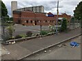
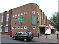
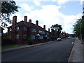
Seventh Day Adventist Church
Cleaning up on Forster Street
Image: © Michael Westley
Taken: 22 May 2022
0.09 miles
3
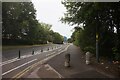
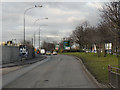
Birmingham, Ashted Circus
Approaching Ashted Circus via the A4540, Lawley Middleway. Notice the different styles of road signs ahead:
· two red triangle (hazard) signs warn respectively of the roundabout and that there are roadworks on the road to the left;
· the brown sign with white lettering is typical of the type of sign used to give directions to tourist attractions. They usually include pictograms; examples in this case include silhouettes of a flower (for the Botanical gardens), a boat (for the canal) etc.
· two temporary signs with black text on a yellow background provide details of diversion routes or direction signs through roadworks.
Image: © David Dixon
Taken: 21 Dec 2012
0.12 miles
4
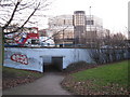
Birmingham Pedestrian Subways
There are still a few around the city centre - this one giving pedestrian access / crossing from south side of Jenners Road to Dartmouth Middleway and Aston Science Park
Image: © Michael Westley
Taken: 4 Mar 2011
0.13 miles
5
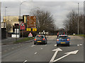
Vauxhall Sports & Social Club, Nechells
Image: © Chris Whippet
Taken: 3 Aug 2014
0.13 miles
6
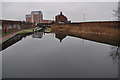
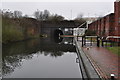
Ashted locks
Although the weather wasn't brilliant light wise the canal was like a mill pond giving great reflections.
I was caught in the act taking this one!
Image]
Image: © Ashley Dace
Taken: 19 Feb 2011
0.13 miles
8
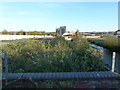
Site of historic pumping station
The weeds in the foreground have grown on the backfilled site of an archaeological excavation of the foundations of a Boulton & Watt canal pumping steam engine. This was the site of the Lawley Street (or Ashted) Pumping Station (started operating 1812) with an 1811 single acting beam pumping engine. The engine is preserved at the Henry Ford Museum in the USA and has a cast iron beam with parallel motion at each end. The cylinder is 36" bore by 7' stroke and rated at 24.1 horsepower at 10 strokes per minute. The engine operated for 110 years. Although the archaeological report - http://archaeologydataservice.ac.uk/catalogue/adsdata/oasis_reports/archaeol1/ahds/dissemination/pdf/archaeol1-36373_1.pdf - states this to be an atmospheric engine, it clearly isn't - it's a low-pressure single acting engine with steam admitted above the piston and a vacuum below (an atmospheric engine has an open topped cylinder with steam being used to create a vacuum below the piston and only the atmosphere above it).
I looked for this with Ashley Dace in February but we completely failed to recognise it for what it is.
Image: © Chris Allen
Taken: 6 Apr 2011
0.13 miles
10
Ashted Canal Tunnel, south portal
Due to the built up nature of this area there are many tunnels and bridges over the canal. On a flat day like this it had a spooky feel to it, made worse by some of the passers by!
The tunnel is 94 metres long.
See also Image
Image: © Ashley Dace
Taken: 19 Feb 2011
0.14 miles