IMAGES TAKEN NEAR TO
Becket Close, SUTTON COLDFIELD, B74 4XP
Introduction
This page details the photographs taken nearby to Becket Close, B74 4XP by members of the Geograph project.
The Geograph project started in 2005 with the aim of publishing, organising and preserving representative images for every square kilometre of Great Britain, Ireland and the Isle of Man.

There are currently over 7.5m images from over14,400 individuals and you can help contribute to the project by visiting https://www.geograph.org.uk
Image Map
Images are licensed for reuse under creativecommons.org/licenses/by-sa/2.0
Notes
- Clicking on the map will re-center to the selected point.
- The higher the marker number, the further away the image location is from the centre of the postcode.
Image Listing (43 Images Found)
Images are licensed for reuse under creativecommons.org/licenses/by-sa/2.0
Image
Details
Distance
1
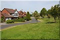
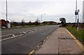
Becket Close
Becket Close beside Lichfield Road at Watford Gap in the northern suburbs of Sutton Coldfield.
Image: © Philip Halling
Taken: 17 May 2018
0.02 miles
2
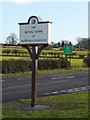
Sutton Coldfield town sign on Lichfield Road
Some time ago the sign was relocated from the roadside to private land adjacent. More recently it disappeared. On Thursday 16 February 2012 it re-appeared, completely refurbished, at yet another new location on the corner of Lichfield Road and Bishops Way. See previous image Image for more of the story.
Image: © Graham Taylor
Taken: 18 Feb 2012
0.08 miles
3
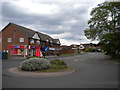
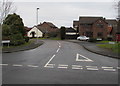
Roundabout on Bishops Way, Hill Hook
Located approximately midway along Bishops Way (at the junction with Shelley Drive), this roundabout is used by buses terminating here to reach the bus stop visible beyond the roundabout.
Image: © Richard Vince
Taken: 3 Jun 2017
0.10 miles
4
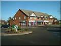
Bishops Way shops
Built in the early '80s when the surrounding housing development was built. Unusually the shop at the right hand end is a doctors' surgery. The traffic island is the terminus for buses into Sutton Coldfield & Birmingham.
Image: © Graham Taylor
Taken: 6 Feb 2008
0.11 miles
6
Towards Shelley Drive, Sutton Coldfield
Viewed from Blake Street railway station.
Image: © Jaggery
Taken: 17 Feb 2018
0.19 miles
8
Bishops Way, Sutton Coldfield
Viewed across Hill Hook Road.
Image: © Jaggery
Taken: 17 Feb 2018
0.19 miles
9
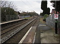
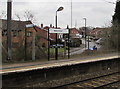
Cross City Line south from Blake Street station, Hill Hook, Sutton Coldfield
Looking towards Hill Hook Road bridge. The next station in this direction is Butlers Lane on the route towards Birmingham New Street. Butlers Lane station is about 1.4km (nearly a mile) from the camera.
Image: © Jaggery
Taken: 17 Feb 2018
0.20 miles
10
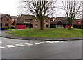
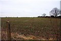
Kestrel Drive houses, Sutton Coldfield
Viewed across Hill Hook Road near the Bishops Way junction.
Image: © Jaggery
Taken: 17 Feb 2018
0.20 miles