IMAGES TAKEN NEAR TO
Thornhill Road, SUTTON COLDFIELD, B74 3ER
Introduction
This page details the photographs taken nearby to Thornhill Road, B74 3ER by members of the Geograph project.
The Geograph project started in 2005 with the aim of publishing, organising and preserving representative images for every square kilometre of Great Britain, Ireland and the Isle of Man.

There are currently over 7.5m images from over14,400 individuals and you can help contribute to the project by visiting https://www.geograph.org.uk
Image Map
Images are licensed for reuse under creativecommons.org/licenses/by-sa/2.0
Notes
- Clicking on the map will re-center to the selected point.
- The higher the marker number, the further away the image location is from the centre of the postcode.
Image Listing (7 Images Found)
Images are licensed for reuse under creativecommons.org/licenses/by-sa/2.0
Image
Details
Distance
1
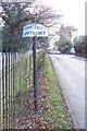
Thornhill Road, Streetly
This is the B4138 down the west side of Sutton Park. The golf-club clubhouse is on the right.
Image: © Adrian Bailey
Taken: 23 Dec 2004
0.01 miles

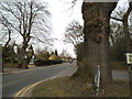
3
Thornhill Road Streetly at Sutton Park, Streetly Gate
Image: © Roy Hughes
Taken: 4 Aug 2021
0.21 miles
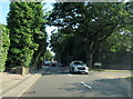
4
Park Gate View
The view from Streetly Gate to Sutton Park down Thornhill Road.
Image: © Gordon Griffiths
Taken: 7 Apr 2013
0.22 miles
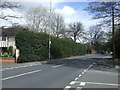
6
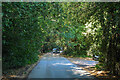
Sutton Coldfield : Sutton Park
A road through Sutton Park.
Image: © Lewis Clarke
Taken: 26 Sep 2020
0.24 miles
7
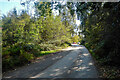
Sutton Coldfield : Sutton Park
A road heads through the park.
Image: © Lewis Clarke
Taken: 26 Sep 2020
0.25 miles