IMAGES TAKEN NEAR TO
Chester Road, SUTTON COLDFIELD, B74 3DX
Introduction
This page details the photographs taken nearby to Chester Road, B74 3DX by members of the Geograph project.
The Geograph project started in 2005 with the aim of publishing, organising and preserving representative images for every square kilometre of Great Britain, Ireland and the Isle of Man.

There are currently over 7.5m images from over14,400 individuals and you can help contribute to the project by visiting https://www.geograph.org.uk
Image Map
Images are licensed for reuse under creativecommons.org/licenses/by-sa/2.0
Notes
- Clicking on the map will re-center to the selected point.
- The higher the marker number, the further away the image location is from the centre of the postcode.
Image Listing (7 Images Found)
Images are licensed for reuse under creativecommons.org/licenses/by-sa/2.0
Image
Details
Distance
2
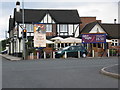
The Hardwick Arms Public House
Situated on Chester Road Streetly.
Image: © Frank Smith
Taken: 30 May 2006
0.09 miles
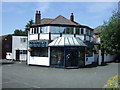
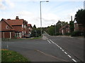
3
The Hardwick Arms
At the junction of A452 Chester Road and Hardwick Road.
Image: © Adrian Rothery
Taken: 6 Aug 2008
0.11 miles

6
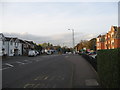
Back to the highway - Hardwick, West Midlands
A view northwards on the A452 Chester Road, while waiting for a return bus home, to the junction of the Chester Road with Foley Road, the B4151 between Walsall and Carroway Head. Time photo taken 4.42 pm BST (British Summer Time).
Image: © Martin Richard Phelan
Taken: 24 Oct 2013
0.15 miles
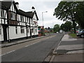
7
Eastwards from Hardwick - Sutton Coldfield, West Midlands
A view eastwards along Hardwick Road, Hardwick, Sutton Coldfield. Time photo taken 2.51 pm BST (British Summer Time).
Image Image
Image: © Martin Richard Phelan
Taken: 24 Oct 2013
0.16 miles