IMAGES TAKEN NEAR TO
Tulip Grove, SUTTON COLDFIELD, B74 2AU
Introduction
This page details the photographs taken nearby to Tulip Grove, B74 2AU by members of the Geograph project.
The Geograph project started in 2005 with the aim of publishing, organising and preserving representative images for every square kilometre of Great Britain, Ireland and the Isle of Man.

There are currently over 7.5m images from over14,400 individuals and you can help contribute to the project by visiting https://www.geograph.org.uk
Image Map
Images are licensed for reuse under creativecommons.org/licenses/by-sa/2.0
Notes
- Clicking on the map will re-center to the selected point.
- The higher the marker number, the further away the image location is from the centre of the postcode.
Image Listing (3 Images Found)
Images are licensed for reuse under creativecommons.org/licenses/by-sa/2.0
Image
Details
Distance
1
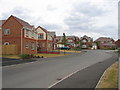
Poet's corner
A new housing estate built on the site of old sand pits just off Aldridge Road.
Image: © David Stowell
Taken: 8 Jul 2006
0.17 miles
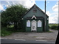
3
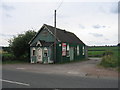
Old schoolroom
At first sight this looks like it could be an old Tin Tabernacle however it is marked on the 1940s OS map as a school. Although showing signs of age it is still in use by a printing company.
Image: © David Stowell
Taken: 8 Jul 2006
0.20 miles