IMAGES TAKEN NEAR TO
Albion Field Drive, WEST BROMWICH, B71 4HN
Introduction
This page details the photographs taken nearby to Albion Field Drive, B71 4HN by members of the Geograph project.
The Geograph project started in 2005 with the aim of publishing, organising and preserving representative images for every square kilometre of Great Britain, Ireland and the Isle of Man.

There are currently over 7.5m images from over14,400 individuals and you can help contribute to the project by visiting https://www.geograph.org.uk
Image Map
Images are licensed for reuse under creativecommons.org/licenses/by-sa/2.0
Notes
- Clicking on the map will re-center to the selected point.
- The higher the marker number, the further away the image location is from the centre of the postcode.
Image Listing (22 Images Found)
Images are licensed for reuse under creativecommons.org/licenses/by-sa/2.0
Image
Details
Distance
1
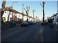
Grafton Road, West Bromwich
Recently trimmed trees line Grafton Road, on which the houses date from roughly the 1950s.
Image: © Richard Law
Taken: 29 Nov 2016
0.08 miles
2
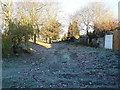
Track at the back of Grafton Road
Rear access to the houses on Grafton Road, and to the garages that many of them have erected in their back gardens.
Image: © Richard Law
Taken: 29 Nov 2016
0.08 miles
3
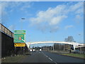
West Bromwich A41 Expressway Junction For A4031 All Saints Way
Image: © Roy Hughes
Taken: 15 Feb 2018
0.10 miles
4
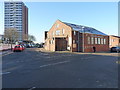
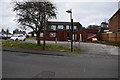
Gospel Blue Ribbon Mission church
Located on the junction of Taylor's Lane and St Clement's Lane, this was formerly known as Grant Hall, and has been occupied by the Mission Church since the late 1960s. The name is taken from a combination of the Gospel Temperance Movement and the Blue Ribbon Army, who held a four-week long mission in West Brom in 1882.
Image: © Richard Law
Taken: 29 Nov 2016
0.11 miles
5
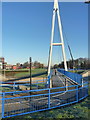
Footbridge over the A41
As part of the extensive redevelopment works around West Brom town centre, the former underpass at this large roundabout (known as the 'Grade Separated Interchange') was replaced in 2012 by this rather striking cable-stayed bridge.
Image: © Richard Law
Taken: 29 Nov 2016
0.12 miles
6
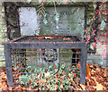
The Lyne Purl Well
Stoney Lane West Bromwich. Close up of Lions Head and commemorative stone.
Image: © R Pitt
Taken: 20 Nov 2018
0.13 miles
7
The Lyne Purl Well
The Lyne Purl Well is situated in a recessed front garden in Stoney Lane. From time immemorial, it was a source of water for the earliest inhabitants of West Bromwich. It was described as "a hollow tree trunk lining a well of soft water".
It is documented in 1606, when the Manor court forbid the washing of “filthy clothes or beasties bellies”. The spring still runs underneath, but is now capped. It bears a lions head and stone inscription which read "Presented by Alderman J.J.Grant J.P. to the town of West Bromwich May 1956"
Image: © R Pitt
Taken: 20 Nov 2018
0.13 miles
8
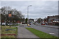
All Saints Way - West Bromwich, West Midlands
A view from beside the Hargate Arms looking north-north-east along All Saints Way, West Bromwich. This is the A4031 (A - A road) which links the A4148 West Broadway at Walsall Image with the A457 at West Smethwick Image Time photo taken 1.00 pm GMT (Greenwich Mean Time).
Image: © Martin Richard Phelan
Taken: 2 Jan 2020
0.14 miles
9
Hargate Arms from west - West Bromwich, West Midlands
This is the former Hargate Arms pub (public house) which has stood here on All Saints Way in West Bromwich for some time since its closure. The property is still available, at the time of writing, for viewing by interested purchasers. The pub sign reads 'Hargate Arms Virtute Et Industria' meaning 'Virtue and Industry'. Time photo taken 12.48 pm GMT (Greenwich Mean Time).
Image: © Martin Richard Phelan
Taken: 2 Jan 2020
0.15 miles
10
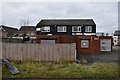
Hargate Arms from east - West Bromwich, West Midlands
This is the former Hargate Arms pub (public house) which has stood here on All Saints Way in West Bromwich for some time since its closure. The property is still available, at the time of writing, for viewing by interested purchasers. The pub sign reads 'Hargate Arms Virtute Et Industria' meaning 'Virtue and Industry'. Time photo taken 12.38 pm GMT (Greenwich Mean Time).
Image: © Martin Richard Phelan
Taken: 2 Jan 2020
0.15 miles