1
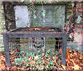
Site of a former OS benchmark - Hallam Street
A one-time OS cutmark existed on this brick pillar, but must have been removed at some time when the wall was repaired, and has been 'replaced' by this rather poor representation.
Image: © Richard Law
Taken: 29 Nov 2016
0.11 miles
2
Gospel Blue Ribbon Mission church
Located on the junction of Taylor's Lane and St Clement's Lane, this was formerly known as Grant Hall, and has been occupied by the Mission Church since the late 1960s. The name is taken from a combination of the Gospel Temperance Movement and the Blue Ribbon Army, who held a four-week long mission in West Brom in 1882.
Image: © Richard Law
Taken: 29 Nov 2016
0.12 miles
3
The Lyne Purl Well
The Lyne Purl Well is situated in a recessed front garden in Stoney Lane. From time immemorial, it was a source of water for the earliest inhabitants of West Bromwich. It was described as "a hollow tree trunk lining a well of soft water".
It is documented in 1606, when the Manor court forbid the washing of “filthy clothes or beasties bellies”. The spring still runs underneath, but is now capped. It bears a lions head and stone inscription which read "Presented by Alderman J.J.Grant J.P. to the town of West Bromwich May 1956"
Image: © R Pitt
Taken: 20 Nov 2018
0.17 miles
4
The Lyne Purl Well
Stoney Lane West Bromwich. Close up of Lions Head and commemorative stone.
Image: © R Pitt
Taken: 20 Nov 2018
0.18 miles
5
OS benchmark - Lyndon, Hallam St
A clear OS cutmark on the wall outside the hospital (the part that is described as the Union Workhouse on older maps.) It was originally levelled at 504 feet 6 inches, but was last checked and relevelled in 1962 at 153.528m above Ordnance Datum Newlyn.
Image: © Richard Law
Taken: 29 Nov 2016
0.18 miles
6
The Crown and Cushion, Mayer's Green
Located at the junction of Seagar Street and Lloyd's Dagger Lane.
Image: © Richard Law
Taken: 29 Nov 2016
0.19 miles
7
Hill House, Dagger Lane, West Bromwich
Hill House dates from the early 16th century In 1839 it was the Home of Captain James EATON (1783 - 1857). During the battle of TRAFALGAR Eaton was a mishipman aboard HMS Temeraire and was the first person to pass on NELSONS famous signal " England expects that every man this day will do his Duty". He is buried at All Saints Churchyard, West Bromwich.
It is reputed that CHARLES DICKENS author was a visitor to Hill House and was staying there about the time that he wrote "The Old Curiosity Shop"
Image: © R Pitt
Taken: 16 Nov 2018
0.19 miles
8
Crown & Cushion, Mayers Green
This pub, in the intersection of Lloyd Street and Seagar street, is convenient for visitors to Dartmouth Park.
Image: © Stephen McKay
Taken: 20 Feb 2017
0.19 miles
9
Sandwell Valley
The little bit of countryside that's left in the conurbation, seen from Salter's Lane.
Image: © Adrian Bailey
Taken: 4 Mar 2005
0.21 miles
10
Dartmouth Park
Dartmouth Park was first opened to the public in 1878 following a request to the 5th Earl of Dartmouth to lease land from the Dartmouth Estate in order to provide West Bromwich with a park. It has been an important part of the life of the area ever since but declined in the latter part of the 20th century, not least because a new road divided the park from the town centre. However, it has since been restored to something of its former glory using heritage lottery funding.
Image: © Stephen McKay
Taken: 20 Feb 2017
0.22 miles


