IMAGES TAKEN NEAR TO
Park Crescent, WEST BROMWICH, B71 4AJ
Introduction
This page details the photographs taken nearby to Park Crescent, B71 4AJ by members of the Geograph project.
The Geograph project started in 2005 with the aim of publishing, organising and preserving representative images for every square kilometre of Great Britain, Ireland and the Isle of Man.

There are currently over 7.5m images from over14,400 individuals and you can help contribute to the project by visiting https://www.geograph.org.uk
Image Map
Images are licensed for reuse under creativecommons.org/licenses/by-sa/2.0
Notes
- Clicking on the map will re-center to the selected point.
- The higher the marker number, the further away the image location is from the centre of the postcode.
Image Listing (24 Images Found)
Images are licensed for reuse under creativecommons.org/licenses/by-sa/2.0
Image
Details
Distance
1
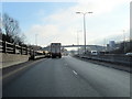
Footbridge Over West Bromwich A41 Expressway
Image: © Roy Hughes
Taken: 18 Dec 2017
0.05 miles
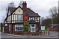
3
The Crown and Cushion, Mayer's Green
Located at the junction of Seagar Street and Lloyd's Dagger Lane.
Image: © Richard Law
Taken: 29 Nov 2016
0.07 miles
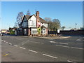
4
Crown & Cushion, Mayers Green
This pub, in the intersection of Lloyd Street and Seagar street, is convenient for visitors to Dartmouth Park.
Image: © Stephen McKay
Taken: 20 Feb 2017
0.07 miles
5
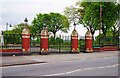
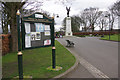
Dartmouth Park entrance gates, Reform Street, West Bromwich
The gates in Reform Street give access to The Drive, on which the impressive war memorial is located, and which leads on to a drinking fountain and the Sensory Garden.
Image: © P L Chadwick
Taken: 13 May 2017
0.09 miles
6
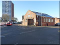
Gospel Blue Ribbon Mission church
Located on the junction of Taylor's Lane and St Clement's Lane, this was formerly known as Grant Hall, and has been occupied by the Mission Church since the late 1960s. The name is taken from a combination of the Gospel Temperance Movement and the Blue Ribbon Army, who held a four-week long mission in West Brom in 1882.
Image: © Richard Law
Taken: 29 Nov 2016
0.10 miles
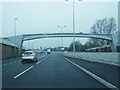
7
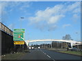
West Bromwich A41 Expressway Junction For A4031 All Saints Way
Image: © Roy Hughes
Taken: 15 Feb 2018
0.11 miles
8
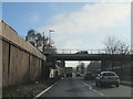
A41 Expressway Passing Under Reform Street West Bromwich
Image: © Roy Hughes
Taken: 18 Dec 2017
0.13 miles
9
Dartmouth Park
Dartmouth Park was first opened to the public in 1878 following a request to the 5th Earl of Dartmouth to lease land from the Dartmouth Estate in order to provide West Bromwich with a park. It has been an important part of the life of the area ever since but declined in the latter part of the 20th century, not least because a new road divided the park from the town centre. However, it has since been restored to something of its former glory using heritage lottery funding.
Image: © Stephen McKay
Taken: 20 Feb 2017
0.13 miles
10
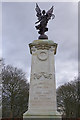
Dartmouth Park War Memorial
The memorial in Dartmouth Park was paid for by public subscription and unveiled in 1923 by the Earl of Dartmouth.
Image: © Stephen McKay
Taken: 20 Feb 2017
0.14 miles