IMAGES TAKEN NEAR TO
Gorsty Close, WEST BROMWICH, B71 3EB
Introduction
This page details the photographs taken nearby to Gorsty Close, B71 3EB by members of the Geograph project.
The Geograph project started in 2005 with the aim of publishing, organising and preserving representative images for every square kilometre of Great Britain, Ireland and the Isle of Man.

There are currently over 7.5m images from over14,400 individuals and you can help contribute to the project by visiting https://www.geograph.org.uk
Image Map
Images are licensed for reuse under creativecommons.org/licenses/by-sa/2.0
Notes
- Clicking on the map will re-center to the selected point.
- The higher the marker number, the further away the image location is from the centre of the postcode.
Image Listing (4 Images Found)
Images are licensed for reuse under creativecommons.org/licenses/by-sa/2.0
Image
Details
Distance
1
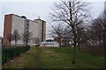
Beacon View, West Bromwich
These socialistic blocks are a familiar sight to drivers on the M5/M6 interchange.
Image: © Adrian Bailey
Taken: 29 Jan 2005
0.12 miles
2
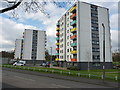
3 blocks of flats on Meadow Avenue
These 3 identical blocks are Aspen House, Willow House and Beech House.
Image: © Richard Law
Taken: 19 Apr 2013
0.12 miles
3
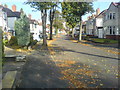
Charlemont Crescent
View of Charlemont Crescent looking North East
Autumn's setting in!
Image: © Peter Ashcroft
Taken: 23 Oct 2007
0.21 miles
4
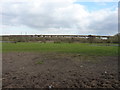
M5 northbound to the M6 eastbound
The elevated section of the M5, heading for the M6 into Birmingham, seen across a rather muddy field east of Charlemont.
Image: © Richard Law
Taken: 19 Apr 2013
0.22 miles