IMAGES TAKEN NEAR TO
Stafford Drive, WEST BROMWICH, B71 2SA
Introduction
This page details the photographs taken nearby to Stafford Drive, B71 2SA by members of the Geograph project.
The Geograph project started in 2005 with the aim of publishing, organising and preserving representative images for every square kilometre of Great Britain, Ireland and the Isle of Man.

There are currently over 7.5m images from over14,400 individuals and you can help contribute to the project by visiting https://www.geograph.org.uk
Image Map
Images are licensed for reuse under creativecommons.org/licenses/by-sa/2.0
Notes
- Clicking on the map will re-center to the selected point.
- The higher the marker number, the further away the image location is from the centre of the postcode.
Image Listing (3 Images Found)
Images are licensed for reuse under creativecommons.org/licenses/by-sa/2.0
Image
Details
Distance
1
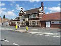
The New Talbot public house
A free house on Black Lake road, the A4196.
Image: © Richard Law
Taken: 27 Jul 2012
0.17 miles
2
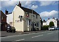
The Sow and Pigs public house
Public house on Black Lane, the A4196 from Wednesbury to West Brom.
Image: © Richard Law
Taken: 27 Jul 2012
0.19 miles
3
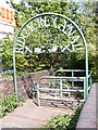
Ridgacre Canal Gate
The path down to the canal from Black Lake road.
Image: © Gordon Griffiths
Taken: 21 Apr 2009
0.23 miles