IMAGES TAKEN NEAR TO
Denbigh Drive, WEST BROMWICH, B71 2RL
Introduction
This page details the photographs taken nearby to Denbigh Drive, B71 2RL by members of the Geograph project.
The Geograph project started in 2005 with the aim of publishing, organising and preserving representative images for every square kilometre of Great Britain, Ireland and the Isle of Man.

There are currently over 7.5m images from over14,400 individuals and you can help contribute to the project by visiting https://www.geograph.org.uk
Image Map
Images are licensed for reuse under creativecommons.org/licenses/by-sa/2.0
Notes
- Clicking on the map will re-center to the selected point.
- The higher the marker number, the further away the image location is from the centre of the postcode.
Image Listing (7 Images Found)
Images are licensed for reuse under creativecommons.org/licenses/by-sa/2.0
Image
Details
Distance
1
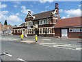
The New Talbot public house
A free house on Black Lake road, the A4196.
Image: © Richard Law
Taken: 27 Jul 2012
0.09 miles
2
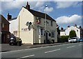
The Sow and Pigs public house
Public house on Black Lane, the A4196 from Wednesbury to West Brom.
Image: © Richard Law
Taken: 27 Jul 2012
0.12 miles
3
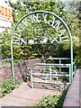
Ridgacre Canal Gate
The path down to the canal from Black Lake road.
Image: © Gordon Griffiths
Taken: 21 Apr 2009
0.18 miles
4
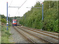
Midland Metro tram line near Black Lake
A Wolverhampton-bound tram accelerates toward the tunnel north of Black Lake tram stop.
Image: © Peter Whatley
Taken: 9 Oct 2008
0.22 miles
5
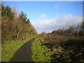
Footpath towards Hill Top, West Bromwich
At this point, the footpath that parallels the Midland Metro tramway through most of West Bromwich rises to a significantly higher level, keeping to the level of the rising ground while the tramway enters a deep cutting on the approach to Hill Top Tunnel.
Image: © Richard Vince
Taken: 9 Feb 2019
0.22 miles
6
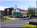
The Chronicle
Newspaper offices of the Express and Star Group on Black Lake Road.
Image: © Gordon Griffiths
Taken: 21 Apr 2009
0.22 miles
7
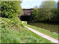
Black Lake Bridge
The bridge over the Ridgacre Canal.
Image: © Gordon Griffiths
Taken: 21 Apr 2009
0.22 miles