IMAGES TAKEN NEAR TO
Heath Lane, WEST BROMWICH, B71 2BG
Introduction
This page details the photographs taken nearby to Heath Lane, B71 2BG by members of the Geograph project.
The Geograph project started in 2005 with the aim of publishing, organising and preserving representative images for every square kilometre of Great Britain, Ireland and the Isle of Man.

There are currently over 7.5m images from over14,400 individuals and you can help contribute to the project by visiting https://www.geograph.org.uk
Image Map
Images are licensed for reuse under creativecommons.org/licenses/by-sa/2.0
Notes
- Clicking on the map will re-center to the selected point.
- The higher the marker number, the further away the image location is from the centre of the postcode.
Image Listing (13 Images Found)
Images are licensed for reuse under creativecommons.org/licenses/by-sa/2.0
Image
Details
Distance
1
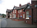
Heath Lane Hospital
This hospital in Heath Lane specialises in care for those with learning disabilities and in need of complex health care.
Image: © David Stowell
Taken: 8 Jul 2006
0.10 miles

4
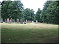
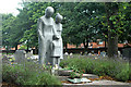
Heath Lane Cemetery
The eastern side of this large cemetery in Charlemont.
Image: © David Stowell
Taken: 8 Jul 2006
0.18 miles
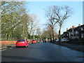
7
West Bromwich Heath Lane and Vicarage Road Junction
Image: © Roy Hughes
Taken: 15 Feb 2018
0.21 miles
8
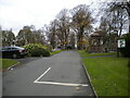
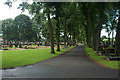
Heath Lane Cemetery, Hall End
Seen from the vehicular entrance off Heath Lane.
Image: © Richard Vince
Taken: 13 Nov 2021
0.21 miles
9
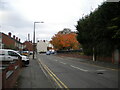
Heath Lane, Hall End
Seen from its junction with Vicarage Road as it passes Heath Lane Cemetery (right).
Image: © Richard Vince
Taken: 13 Nov 2021
0.21 miles
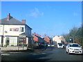
10
West Bromwich Walsall Road Passing Cemetery
Image: © Roy Hughes
Taken: 15 Feb 2018
0.23 miles