IMAGES TAKEN NEAR TO
Griffiths Road, WEST BROMWICH, B71 2BA
Introduction
This page details the photographs taken nearby to Griffiths Road, B71 2BA by members of the Geograph project.
The Geograph project started in 2005 with the aim of publishing, organising and preserving representative images for every square kilometre of Great Britain, Ireland and the Isle of Man.

There are currently over 7.5m images from over14,400 individuals and you can help contribute to the project by visiting https://www.geograph.org.uk
Image Map
Images are licensed for reuse under creativecommons.org/licenses/by-sa/2.0
Notes
- Clicking on the map will re-center to the selected point.
- The higher the marker number, the further away the image location is from the centre of the postcode.
Image Listing (16 Images Found)
Images are licensed for reuse under creativecommons.org/licenses/by-sa/2.0
Image
Details
Distance
1
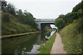
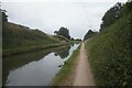
Tame Valley Canal at Crankhall Lane Basin Bridge
Image: © Ian S
Taken: 25 Jul 2021
0.07 miles
2
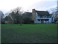
West Bromwich Manor House
Seen late on a January afternoon this timber framed building was erected by the de Marnham family in the late 13th century. At that time this was their agricultural estate in what is today West Bromwich. Of the original complex only the Great Hall survives. It was heavily extended and modernised over the years to the extent that in 1790 it was described as “a large pile of irregular half-timbered buildings, black and white, and surrounded with numerous out-houses and lofty walls.”
By the 1950s it was hidden behind cladding and plastering and narrowly escaped demolition in the 1950s. Fortunately however West Bromwich Corporation carried out an extensive and sympathetic restoration and the Manor House is now a bar and restaurant.
Image: © David Stowell
Taken: 20 Jan 2007
0.08 miles
3
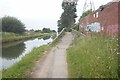
Missing Bridge - Tame Valley Canal
In the foreground, a bridge no longer required. Beyond that, the Crankhill Lane Bridge.
Image: © Adrian Rothery
Taken: 26 Apr 2007
0.08 miles
4
Tame Valley Canal at Crankhall Lane Basin Bridge
Image: © Ian S
Taken: 25 Jul 2021
0.09 miles
5
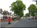
Postbox at Moorlands Road
Taken on Hydes Road a few yards before it transmutes into Hall Green Road.
Image: © Peter Whatley
Taken: 11 May 2010
0.09 miles
6
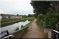
Tame Valley Canal towards Hateley Heath Aqueduct
Image: © Ian S
Taken: 25 Jul 2021
0.09 miles
8
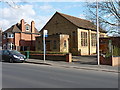
Moorlands Methodist Church
A small church on Hydes Road.
Image: © Richard Law
Taken: 19 Apr 2013
0.16 miles
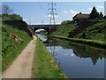
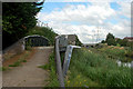
9
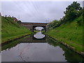
Crankhall Lane Bridge
The bridge crosses the Tame Valley Canal
Image: © Nick Atty
Taken: 27 May 2001
0.17 miles