IMAGES TAKEN NEAR TO
Great Gable Road, WEST BROMWICH, B71 1DW
Introduction
This page details the photographs taken nearby to Great Gable Road, B71 1DW by members of the Geograph project.
The Geograph project started in 2005 with the aim of publishing, organising and preserving representative images for every square kilometre of Great Britain, Ireland and the Isle of Man.

There are currently over 7.5m images from over14,400 individuals and you can help contribute to the project by visiting https://www.geograph.org.uk
Image Map
Images are licensed for reuse under creativecommons.org/licenses/by-sa/2.0
Notes
- Clicking on the map will re-center to the selected point.
- The higher the marker number, the further away the image location is from the centre of the postcode.
Image Listing (3 Images Found)
Images are licensed for reuse under creativecommons.org/licenses/by-sa/2.0
Image
Details
Distance
1
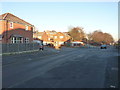
New housing on Sussex Avenue, Hateley Heath
The area appears to have been substantially redeveloped in recent years.
Image: © Richard Law
Taken: 29 Nov 2016
0.11 miles
2
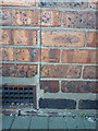
OS benchmark - Hateley Heath, 1 Tame Crescent
An OS cutmark on the wall of the house; originally levelled, probably in 1962, at 133.499m above Ordnance Datum Newlyn.
Image: © Richard Law
Taken: 29 Nov 2016
0.13 miles
3
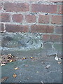
OS benchmark - Hateley Heath, building on Church Lane
An OS cutmark on the former doorstep of a works building on the SE side of Church Lane; originally levelled, probably in 1962, at 134.819m above Ordnance Datum Newlyn.
Image: © Richard Law
Taken: 29 Nov 2016
0.17 miles