IMAGES TAKEN NEAR TO
Oak Road, WEST BROMWICH, B70 8HR
Introduction
This page details the photographs taken nearby to Oak Road, B70 8HR by members of the Geograph project.
The Geograph project started in 2005 with the aim of publishing, organising and preserving representative images for every square kilometre of Great Britain, Ireland and the Isle of Man.

There are currently over 7.5m images from over14,400 individuals and you can help contribute to the project by visiting https://www.geograph.org.uk
Image Map
Images are licensed for reuse under creativecommons.org/licenses/by-sa/2.0
Notes
- Clicking on the map will re-center to the selected point.
- The higher the marker number, the further away the image location is from the centre of the postcode.
Image Listing (66 Images Found)
Images are licensed for reuse under creativecommons.org/licenses/by-sa/2.0
Image
Details
Distance
1
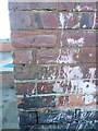
OS benchmark - West Bromwich, 9 Richard St South
Barely visible in amongst the splatter of paint lies an OS cutmark on the wall, which was originally levelled at 163.824m above Ordnance Datum Newlyn.
Image: © Richard Law
Taken: 29 Nov 2016
0.06 miles
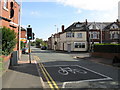
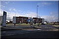
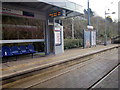
4
Lodge Road tram stop
One of the generic designs for the Midland Metro tram system. The tram is heading for Birmingham's Snow Hill railway station.
Image: © Peter Whatley
Taken: 9 Oct 2008
0.11 miles
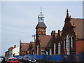
5
Fortress on Moor Street - West Bromwich, West Midlands
Standing to the south-west of the Birmingham - Wolverhampton Metro tram line, this imposing building is the West Bromwich Police Station. This view was taken from near the junction of Lyng Lane and Moor Street. A stub of Lyng Lane crosses by bridge over the Metro line and then over the West Bromwich Ringway to reach the Bus Station. There are or were plans to close a total of 24 Birmingham police stations but whether this expensively built edifice will join them I know not. Time photo taken 12.59 pm GMT (Greenwich Mean Time). Image Image
Image: © Martin Richard Phelan
Taken: 13 Feb 2020
0.11 miles
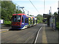
6
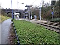
Lodge Road / West Bromwich Town Hall tram stop, West Midlands
Opened in 1999 on the tram line from Birmingham to Wolverhampton.
View north west towards Dartmouth Street tram stop and Wolverhampton.
Image: © Nigel Thompson
Taken: 24 Jan 2018
0.11 miles
7
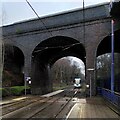
Lodge Road crosses the Metro line, West Bromwich
The Lodge Road bridge is viewed here from the Lodge Road West Bromwich Town Hall metro station. A tram from Wolverhampton is approaching the station. The metro trams have used this line from Wolverhampton to Birmingham since 1999. It follows the course of the former Birmingham to Wolverhampton Low Level Line that was built by the Great Western Railway (GWR) between 1851 and 1854, as part of the GWR's route from London Paddington to Birkenhead Woodside. Passenger services were withdrawn in 1972; see Wikipedia https://en.wikipedia.org/wiki/Birmingham_Snow_Hill_to_Wolverhampton_Low_Level_Line .
Image: © A J Paxton
Taken: 16 Mar 2023
0.11 miles
8
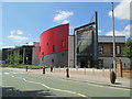
West Bromwich Leisure Centre
On Moor Street, south-west of the town centre.
Image: © David Weston
Taken: 15 Jul 2018
0.11 miles
10
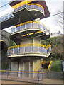
Lift and Staircase Lodge Road Metro Station
Image: © Roy Hughes
Taken: 5 Mar 2016
0.12 miles