IMAGES TAKEN NEAR TO
Cottrell Mews, WEST BROMWICH, B70 7BG
Introduction
This page details the photographs taken nearby to Cottrell Mews, B70 7BG by members of the Geograph project.
The Geograph project started in 2005 with the aim of publishing, organising and preserving representative images for every square kilometre of Great Britain, Ireland and the Isle of Man.

There are currently over 7.5m images from over14,400 individuals and you can help contribute to the project by visiting https://www.geograph.org.uk
Image Map
Images are licensed for reuse under creativecommons.org/licenses/by-sa/2.0
Notes
- Clicking on the map will re-center to the selected point.
- The higher the marker number, the further away the image location is from the centre of the postcode.
Image Listing (24 Images Found)
Images are licensed for reuse under creativecommons.org/licenses/by-sa/2.0
Image
Details
Distance
1
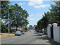
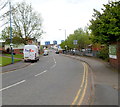
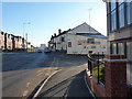
Lyttleton Street, West Bromwich
Looking along Lyttleton Street, from the junction with Bromford Lane.
Image: © David Weston
Taken: 15 Jul 2018
0.05 miles
2
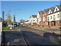
New flats and housing on Lyttleton Street, West Bromwich
Image: © Richard Law
Taken: 29 Nov 2016
0.05 miles
3
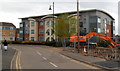
Modern flats, West Bromwich
Viewed from Bromford Lane. This is the Turks Head Way side of a block of flats on the corner of The Sidings. The fenced-off site on the right is part of the Lyng Regeneration Project. http://www.geograph.org.uk/photo/2934157
Image: © Jaggery
Taken: 5 May 2012
0.06 miles
4
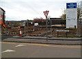
A corner of the Lyng Regeneration project, West Bromwich
Viewed at the corner of Turks Head Way and Bromford Lane, opposite the post office. http://www.geograph.org.uk/photo/2933917
The Lyng regeneration is a Sandwell Council project, in partnership with Barratt Homes and the Lyng Community Association. When complete, there will be about 250 new dwellings for private sale, new public open spaces and parks, and a new office for the Lyng Community Association.
Image: © Jaggery
Taken: 5 May 2012
0.06 miles
5
Lyttleton Street, West Bromwich
Viewed from the edge of the White Swan http://www.geograph.org.uk/photo/2933908 looking along Lyttleton Street towards Sams Lane.
Image: © Jaggery
Taken: 5 May 2012
0.09 miles
6
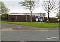
Good Shepherd with St John Parish Church, West Bromwich
Anglican parish church in The Lyng on the corner of Lyttleton Street and Bromford Lane.
The church, part of the Diocese of Lichfield, was consecrated in 1968.
Image: © Jaggery
Taken: 5 May 2012
0.09 miles
7
White Swan, West Bromwich
Pub on the corner of Bromford Lane and Lyttleton Street.
Image: © Jaggery
Taken: 5 May 2012
0.09 miles
8
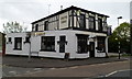
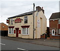
The Prince Albert
A free house on Sams Lane, West Bromwich.
Image: © Richard Law
Taken: 29 Nov 2016
0.10 miles
9
Lyttleton Street leads into Sams Lane
Here at the junction with Horton St and the Prince Albert pub on the right, Lyttleton St changes name to become Sams Lane, leading on to Spon Lane in about 1/4 of a mile.
Image: © Richard Law
Taken: 29 Nov 2016
0.11 miles
10
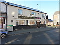
The Royal Exchange, West Bromwich
Pub at 84 Bromford Lane.
Image: © Jaggery
Taken: 5 May 2012
0.12 miles