IMAGES TAKEN NEAR TO
Mountbatten Close, WEST BROMWICH, B70 6QN
Introduction
This page details the photographs taken nearby to Mountbatten Close, B70 6QN by members of the Geograph project.
The Geograph project started in 2005 with the aim of publishing, organising and preserving representative images for every square kilometre of Great Britain, Ireland and the Isle of Man.

There are currently over 7.5m images from over14,400 individuals and you can help contribute to the project by visiting https://www.geograph.org.uk
Image Map
Images are licensed for reuse under creativecommons.org/licenses/by-sa/2.0
Notes
- Clicking on the map will re-center to the selected point.
- The higher the marker number, the further away the image location is from the centre of the postcode.
Image Listing (22 Images Found)
Images are licensed for reuse under creativecommons.org/licenses/by-sa/2.0
Image
Details
Distance
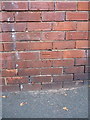
1
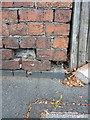
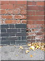
OS benchmark - West Bromwich, Beeches Road
An OS cutmark on a rather shabby piece of wall on the NE side of Beeches Road; originally levelled at 166.354m above Ordnance Datum Newlyn.
Image: © Richard Law
Taken: 23 Oct 2015
0.04 miles
2
OS benchmark - West Bromwich, Beeches Road
The rather badly damaged remains of an OS benchmark on the SW side of Beeches Road, of which the datum line marked in yellow paint is all that's left when the new wall on the left was cut in; originally levelled at 168.301m above Ordnance Datum Newlyn.
Image: © Richard Law
Taken: 23 Oct 2015
0.05 miles
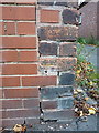
3
OS benchmark - West Bromwich, 43 Birmingham Road
An OS cutmark on the roadside wall that would have bounded the gardens of the (now demolished) row of houses along this end of the Birmingham Road. The new brickwork on the right seals the former gateway. Mark originally levelled at 166.64m above Ordnance Datum Newlyn.
Image: © Richard Law
Taken: 23 Oct 2015
0.07 miles
6
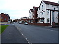
New developments, Beeches Road
New flats and apartments on the NE side of Beeches Road, West Brom.
Image: © Richard Law
Taken: 23 Oct 2015
0.15 miles
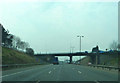
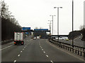
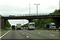
7
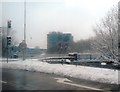
M5 Junction 1 Roundabout from the Slip Road
Image: © Anthony Parkes
Taken: 23 Mar 2013
0.16 miles
8
OS benchmark - West Bromwich, 62 Beeches Road
An OS cutmark on the side wall of 62 Beeches Road; originally levelled at 171.91m above Ordnance Datum Newlyn.
Image: © Richard Law
Taken: 23 Oct 2015
0.16 miles