IMAGES TAKEN NEAR TO
Glover Street, WEST BROMWICH, B70 6EB
Introduction
This page details the photographs taken nearby to Glover Street, B70 6EB by members of the Geograph project.
The Geograph project started in 2005 with the aim of publishing, organising and preserving representative images for every square kilometre of Great Britain, Ireland and the Isle of Man.

There are currently over 7.5m images from over14,400 individuals and you can help contribute to the project by visiting https://www.geograph.org.uk
Image Map
Images are licensed for reuse under creativecommons.org/licenses/by-sa/2.0
Notes
- Clicking on the map will re-center to the selected point.
- The higher the marker number, the further away the image location is from the centre of the postcode.
Image Listing (56 Images Found)
Images are licensed for reuse under creativecommons.org/licenses/by-sa/2.0
Image
Details
Distance
4
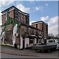
The Cricketers' Arms, Glover Street. West Bromwich
The Cricketers' Arms has a fine gable end mural facing onto Kenrick Way (I have left off the brewery advertising to the left of the wicket, though). The tower blocks in the background are Neale House and Macauley House; they are adorned with the 'butterfly excrescences' (Image]) that feature on many tower blocks in the West Midlands.
Image: © A J Paxton
Taken: 15 Apr 2023
0.06 miles
8
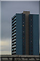
Sandwell : Greenford House
A block of flats seen in Sandwell.
Image: © Lewis Clarke
Taken: 21 Apr 2016
0.11 miles
9
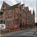
Kenrick Building, Hall Street South, West Bromwich
This vast red brick Gothic pile was built in the 1880s as offices and stores for the cast iron founders Archibald Kenrick & Sons. It is a Grade II listed building, described on the Historic England site https://historicengland.org.uk/listing/the-list/list-entry/1342664?section=official-list-entry , but appears to be unused and has a sign on it saying 'Haliburton House, formerly Kenrick Building'. It is a prominent landmark for travellers on the M5 motorway, which passes the site on a viaduct, just visible at the right hand side of the photo.
Archibald Kenrick began casting ironware on this site by Spon Lane in the early 1790s; the Kenricks became successful businessmen and prominent local philanthropists, with a number of sites named after them, such as Kenrick Park, as explained by the West Bromwich Local History Society https://www.westbromwichhistory.com/people-places/archibald-kenrick/ . The firm is still in business in neighbouring buildings, privately owned by Spire Manufacturing and making window and door hardware; see their website, which is illustrated with an aerial photo of the buildings https://www.kenricks.co.uk/about-us-2/introduction-to-kenricks/ .
Image: © A J Paxton
Taken: 15 Apr 2023
0.13 miles