1
Sandwell : Greenford House
A block of flats seen in Sandwell.
Image: © Lewis Clarke
Taken: 21 Apr 2016
0.03 miles
2
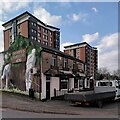
The Cricketers' Arms, Glover Street. West Bromwich
The Cricketers' Arms has a fine gable end mural facing onto Kenrick Way (I have left off the brewery advertising to the left of the wicket, though). The tower blocks in the background are Neale House and Macauley House; they are adorned with the 'butterfly excrescences' (
Image]) that feature on many tower blocks in the West Midlands.
Image: © A J Paxton
Taken: 15 Apr 2023
0.06 miles
3
The Cricketers Arms, West Bromwich
Image: © Chris Whippet
Taken: 21 Dec 2013
0.07 miles
4
Steel & Alloy processing, Union Street, West Bromwich
A large works with a nice old office building squeezed between two more modern large sheds. Much of the Black Country's industry seems to occur in rather undistinguished 'sheds'.
Image: © Chris Allen
Taken: 12 Feb 2020
0.09 miles
5
Glover Street, West Bromwich
Image: © Chris Whippet
Taken: 21 Dec 2013
0.09 miles
6
Birmingham : City Scenery
Looking across the city towards a block of flats.
Image: © Lewis Clarke
Taken: 29 Oct 2013
0.10 miles
7
Constance Avenue, West Bromwich
Image: © Chris Whippet
Taken: 21 Dec 2013
0.10 miles
8
Tower Blocks on Kenrick Way
These blocks are getting a facelift. Sandwell has demolished a number of the older blocks within the borough.
Image: © John M
Taken: 17 Jan 2009
0.10 miles
9
Kenrick House, Green Street, West Bromwich
Image: © Chris Whippet
Taken: 21 Dec 2013
0.10 miles
10
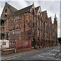
Kenrick Building, Hall Street South, West Bromwich
This vast red brick Gothic pile was built in the 1880s as offices and stores for the cast iron founders Archibald Kenrick & Sons. It is a Grade II listed building, described on the Historic England site https://historicengland.org.uk/listing/the-list/list-entry/1342664?section=official-list-entry , but appears to be unused and has a sign on it saying 'Haliburton House, formerly Kenrick Building'. It is a prominent landmark for travellers on the M5 motorway, which passes the site on a viaduct, just visible at the right hand side of the photo.
Archibald Kenrick began casting ironware on this site by Spon Lane in the early 1790s; the Kenricks became successful businessmen and prominent local philanthropists, with a number of sites named after them, such as Kenrick Park, as explained by the West Bromwich Local History Society https://www.westbromwichhistory.com/people-places/archibald-kenrick/ . The firm is still in business in neighbouring buildings, privately owned by Spire Manufacturing and making window and door hardware; see their website, which is illustrated with an aerial photo of the buildings https://www.kenricks.co.uk/about-us-2/introduction-to-kenricks/ .
Image: © A J Paxton
Taken: 15 Apr 2023
0.11 miles


