IMAGES TAKEN NEAR TO
Spon Lane, WEST BROMWICH, B70 6AB
Introduction
This page details the photographs taken nearby to Spon Lane, B70 6AB by members of the Geograph project.
The Geograph project started in 2005 with the aim of publishing, organising and preserving representative images for every square kilometre of Great Britain, Ireland and the Isle of Man.

There are currently over 7.5m images from over14,400 individuals and you can help contribute to the project by visiting https://www.geograph.org.uk
Image Map
Images are licensed for reuse under creativecommons.org/licenses/by-sa/2.0
Notes
- Clicking on the map will re-center to the selected point.
- The higher the marker number, the further away the image location is from the centre of the postcode.
Image Listing (34 Images Found)
Images are licensed for reuse under creativecommons.org/licenses/by-sa/2.0
Image
Details
Distance
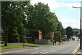
1
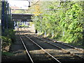
Midland Metro tram line near Trinity Way
The view is toward Wolverhampton along what was once the Great Western Railway's main line from London to Shrewsbury, Chester and Birkenhead.
Image: © Peter Whatley
Taken: 9 Oct 2008
0.04 miles
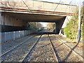
2
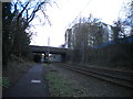
Path and tramway east of Spon Lane, West Bromwich
The bridge carrying Spon Lane is a short way ahead, with the great bulk of the Central Campus of Sandwell College visible beyond on the right.
Image: © Richard Vince
Taken: 9 Feb 2019
0.05 miles
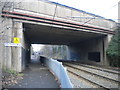
3
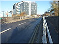
Spon Lane railway bridge
The bridge carries Spon Lane over the former railway, now occupied by the Midland Metro tramline, whilst the background is dominated by the Central Campus building of Sandwell College.
Image: © Richard Law
Taken: 29 Nov 2016
0.06 miles
4
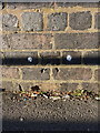
OS benchmark - West Bromwich, Spon Lane railway bridge
An OS cutmark on the western parapet wall of the bridge on Spon Lane; originally levelled at 160.371m above Ordnance Datum Newlyn.
Image: © Richard Law
Taken: 29 Nov 2016
0.07 miles
5
Spon Lane, West Bromwich
During the 1950's & 60's this road to west Smethwick contained more pubs than you could shake a stick at. Today, I believe, it contains just one.
Image: © Row17
Taken: 27 Jul 2009
0.08 miles
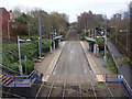
6
Midland Metro line under Trinity Way
Looking NW along the tram route, in the general direction of Wolverhampton. The next stop in that direction is West Bromwich Central.
Image: © Richard Law
Taken: 29 Nov 2016
0.14 miles
7
Path and tramway passing beneath Trinity Way, West Bromwich
The path parallels the Midland Metro tramway as the latter passes through West Bromwich.
Image: © Richard Vince
Taken: 9 Feb 2019
0.14 miles
8
Trinity Way tram stop, West Midlands
Opened in 1999 on the tram line from Birmingham to Wolverhampton.
View south east towards Kenrick Park tram stop and Birmingham.
Image: © Nigel Thompson
Taken: 24 Jan 2018
0.18 miles
9
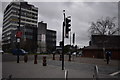
From Dartmouth Square 3 - West Bromwich, West Midlands
On this overcast day in February a view southwards from Dartmouth Square to the West Bromwich Ringway. Time photo taken 1.50 pm GMT (Greenwich Mean Time).
Image] Image]
Image: © Martin Richard Phelan
Taken: 21 Feb 2020
0.18 miles
10
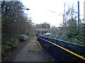
Footpath to Trinity Way tram stop, West Bromwich
Reaching rail level immediately to the east of the bridge carrying Trinity Way.
Image: © Richard Vince
Taken: 9 Feb 2019
0.19 miles